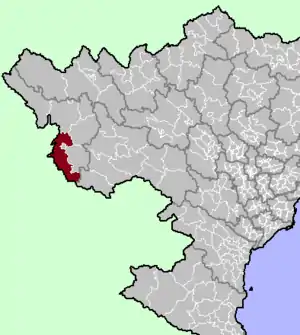
Điện Biên District
Huyện Điện Biên | |
|---|---|
 District location in northern Vietnam | |
| Country | |
| Region | Northwest |
| Province | Điện Biên |
| Capital | Thanh Xương |
| Area | |
| • Total | 1,395.99 km2 (538.99 sq mi) |
| Population (2019)[1] | |
| • Total | 93,850 |
| • Density | 67/km2 (170/sq mi) |
| Time zone | UTC+7 (Indochina Time) |
Điện Biên (ⓘ) is a district of Vietnam's Điện Biên province. As of 2019, it had a population of 93,850 people, covering an area of 1395.99 km²,[1] making it the most populous district in the province. The district capital lies at Thanh Xương.[2] It is bordered by Sơn La province, Mường Chà district, Điện Biên Đông district, Điện Biên Phủ, and Phongsaly province of Laos.
Administrative divisions
The district is officially divided into 21 commune-level sub-divisions[1] (Hẹ Muông, Hua Thanh, Mường Lói, Mường Nhà, Mường Pồn, Na Tông, Na Ư, Noong Hẹt, Noong Luống, Núa Ngam, Pa Thơm, Phu Luông, Pom Lót, Sam Mứn, Thanh An, Thanh Chăn, Thanh Hưng, Thanh Luông, Thanh Nưa, Thanh Xương, Thanh Yên).
References
- 1 2 3 4 "Nghị quyết số 815/NQ-UBTVQH14 năm 2019 về việc sắp xếp các đơn vị hành chính cấp huyện, cấp xã thuộc tỉnh Điện Biên". 2019-11-21.
- ↑ "Districts of Vietnam". Retrieved January 21, 2017.
This article is issued from Wikipedia. The text is licensed under Creative Commons - Attribution - Sharealike. Additional terms may apply for the media files.
