 | |
| Meteorological history | |
|---|---|
| Duration | 1170 |
| Overall effects | |
| Areas affected | Creller Wood |
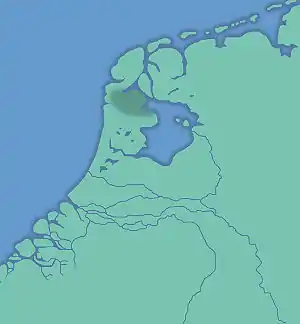
The All Saints' Flood of 1170 (Allerheiligenvloed) was a catastrophic flood in the Netherlands that took place in 1170. Large parts of the Northern Netherlands, and Holland territories were overflowed.
The flooding North Sea created the islands of Wieringen and Texel. Lake Flevo was once a fresh water lake, but a sea channel opened a connection from the North Sea into the lake through Creil Woods. Lake Flevo began to turn into the salt-water sea known as the Zuiderzee. By around 1248, the transformation of the lake into the Zuiderzee was complete.[1] By around 1248, The Creiler Woods vanished under the waves. The sea area increased inside the Netherlands and large peat areas developed, which were easily washed away.
The flood rendered the settlement of Rotta (the predecessor of Rotterdam) uninhabitable,[2] and marked the beginning of Amsterdam, where the area gained an open connection to the sea, and where a dam was built in the Amstel to protect the land from future floods.[3]
See also
References
- ↑ Biggelaar, D. F. A. M. van den; Kluiving, S. J.; Balen, R. T. van; Kasse, C.; Troelstra, S. R.; Prins, M. A. (December 2014). "Storms in a lagoon: Flooding history during the last 1200 years derived from geological and historical archives of Schokland (Noordoostpolder, the Netherlands)". Netherlands Journal of Geosciences. 93 (4): 175–196. doi:10.1017/njg.2014.14. ISSN 0016-7746.
- ↑ Van der Kolk, Donna (3 October 2016). "5x Wat je niet wist over Rotterdamse geschiedenis". Metronieuws.nl (in Dutch). Metro Nieuws. Retrieved 5 January 2021.
- ↑ Van Soest, Arnoud (February 2018). "Amsterdam is in de storm geboren". ONH (in Dutch). Retrieved 5 January 2021.
- Rome's Greatest Defeat, A Review - All Saints' Flood of 1170 Archived 2018-12-09 at the Wayback Machine. File retrieved March 11, 2007.
- Buisman, Jan, Duizend jaar weer, wind en water in de Lage Landen (Deel 1: tot 1300), ISBN 978-90-5194-075-6