Route nationale 618 or RN 618 was a French national road linking Saint-Jean-de-Luz (on the Atlantic Ocean) to Argelès-sur-Mer (on the Mediterranean). En route it crossed many of the famous passes in the Pyrenees, immortalized by the Tour de France; hence its name was the "Route of the Pyrénées". In 1970, the road was down-graded and is now the RD 918 from Saint-Jean-de-Luz to Arreau and the RD 618 from Arreau to Argelès Plage.
Itinerary
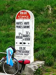
The places named in italic are mountain passes used in the Tour de France.
Common with the former RN 133
Common with RN 134
Common with the former RN 134BIS
Common with the former RN 21
- Luz-Saint-Sauveur
- Barèges
- Col du Tourmalet
- Sainte-Marie-de-Campan
- Col d'Aspin
- Arreau
- Col de Peyresourde
- Bagnères-de-Luchon
Common with the former RN 125
- Saint-Mamet
- Col du Portillon, Spanish frontier.
Route interrupted by the Spanish border
- Chaum
- Col des Ares
- Juzet-d'Izaut
- Col de Portet d'Aspet
- Saint-Lary
- Audressein
- Saint-Girons
- Massat
- Col de Port
- Tarascon-sur-Ariège
Common with RN 20
Common with RN 116
Common with the former RN 115
- Céret
- Le Boulou
- Argelès-sur-Mer
- Argelès Plage
This article is issued from Wikipedia. The text is licensed under Creative Commons - Attribution - Sharealike. Additional terms may apply for the media files.