Doncaster–Mordialloc Road Victoria Street Wetherby Road Middleborough Road Stephensons Road Clayton Road Boundary Road | |
|---|---|
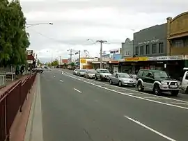 | |
| Clayton Road, Clayton | |
 North end South end | |
| Coordinates | |
| General information | |
| Type | Road |
| Length | 26.9 km (17 mi)[1] |
| Route number(s) |
|
| Major junctions | |
| North end | King Street Templestowe, Melbourne |
| |
| South end | Braeside, Melbourne |
| Location(s) | |
| Major suburbs | Doncaster, Box Hill, Mount Waverley, Clayton |
Doncaster–Mordialloc Road is a major arterial road in the eastern & south-eastern suburbs of Melbourne. This name is not widely known to most drivers, as the entire allocation is still best known as by the names of its constituent parts: Victoria Street, Wetherby Road, Middleborough Road, Stephensons Road, Clayton Road and Boundary Road.[2] This article will deal with the entire length of the corridor for sake of completion, as well to avoid confusion between declarations.
History
Doncaster–Mordialloc Road was signed as Metropolitan Route 23 between Doncaster Road and Wells Road in 1989.
The passing of the Road Management Act 2004[3] granted the responsibility of overall management and development of Victoria's major arterial roads to VicRoads: in 2004, VicRoads declared Doncaster–Mordialloc Road (Arterial #5803) from King Street in Templestowe to Wells Road in Braeside.[2] The road is still presently known (and signposted) as its continuous parts along its entire length.
Major intersections
| LGA | Location | km | mi | Destinations | Notes |
|---|---|---|---|---|---|
| Manningham | Doncaster East–Templestowe boundary | 0 | 0.0 | King Street | Northern terminus of Victoria Street |
| Doncaster | 1.6 | 0.99 | Northern terminus of Metro Route 23 Name change: Victoria Street (north), Wetherby Road (south) | ||
| Whitehorse | Box Hill North–Blackburn North boundary | 2.8 | 1.7 | Diamond interchange Name change: Wetherby Road (north), Middleborough Road (south) | |
| Box Hill–Blackburn boundary | 5.2 | 3.2 | |||
| Box Hill–Blackburn–Box Hill South–Blackburn South quadripoint | 6.4 | 4.0 | |||
| Burwood–Burwood East boundary | 8.9 | 5.5 | |||
| Whitehorse–Monash boundary | Burwood–Burwood East–Mount Waverley tripoint | 9.5 | 5.9 | Highbury Road | Name change: Middleborough Road (north), Stephensons Road (south) |
| Monash | Mount Waverley | 10.9 | 6.8 | ||
| 12.5 | 7.8 | Waverley Road | |||
| Clayton–Oakleigh East–Mount Waverley tripoint | 14.2 | 8.8 | Name change: Stephensons Road (north), Clayton Road (south) | ||
| Clayton–Oakleigh East boundary | 15.6 | 9.7 | |||
| 15.8 | 9.8 | ||||
| Kingston–Monash boundary | Clayton–Clayton South boundary | 17.5 | 10.9 | ||
| Kingston | Clarinda–Clayton South boundary | 20.8 | 12.9 | Name change: Clayton Road (north), Boundary Road (south) | |
| Dingley Village–Heatherton boundary | 21.0 | 13.0 | |||
| 21.8 | 13.5 | Old Dandenong Road – Heatherton, Dingley Village | |||
| Dingley Village–Heatherton–Moorabbin Airport tripoint | 22.5 | 14.0 | |||
| Dingley Village–Mordialloc–Braeside–Moorabbin Airport quadripoint | 24.1 | 15.0 | |||
| Mordialloc–Braeside boundary | 25.7 | 16.0 | White Street (west) Malcolm Road (east) | ||
| 26.4 | 16.4 | ||||
| 26.9 | 16.7 | Southern terminus of Boundary Road Metro Route 23 continues south Wells Road | |||
1.000 mi = 1.609 km; 1.000 km = 0.621 mi
| |||||
Gallery
 Stephensons Road, Mount Waverley
References
- ↑ Google (1 June 2022). "Doncaster–Mordialloc Road" (Map). Google Maps. Google. Retrieved 1 June 2022.
- 1 2 VicRoads. "VicRoads – Register of Public Roads (Part A) 2015" (PDF). Government of Victoria. p. 766. Archived from the original on 1 May 2020. Retrieved 1 June 2022.
- ↑ State Government of Victoria. "Road Management Act 2004" (PDF). Government of Victoria. Archived (PDF) from the original on 18 October 2021. Retrieved 19 October 2021.