National Highway 16 (NH 16) is a major National Highway in India that runs along east coast of West Bengal, Odisha, Andhra Pradesh, and Tamil Nadu.[1] It was previously known as National Highway 5.
The northern terminal starts at Dankuni National Highway 19 near Kolkata and the southern terminal is at Chennai, Tamil Nadu. It is a part of the Golden Quadrilateral project to connect India's major cities.[2][3]
Route
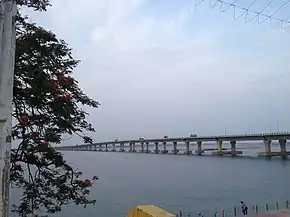
.jpg.webp)
Many cities and towns across the states of West Bengal, Odisha, Andhra Pradesh, Telangana, and Tamil Nadu are connected by National Highway 16. NH 16 has a total length of 1,764 km (1,096 mi) and passes through the states of West Bengal, Odisha, Andhra Pradesh and Tamil Nadu.[4]
Route length in states:[5]
- West Bengal: 206 km (128 mi)
- Odisha: 529 km (329 mi)
- Andhra Pradesh: 992.25 km (616.56 mi)[3]
- Tamil Nadu: 42.75 km (26.56 mi)
Junctions list
- West Bengal
 NH 19 near Kolkata
 NH 12 near Kolkata
 NH 116 near Kolaghat
 NH 116A near Panskura
 NH 14 near Kharagpur
 NH 49 near Kharagpur
- Odisha
 NH 18 near Baleshwar
- NH 316A near Bhadrak
 NH 20 near Panikoili
 NH 53 near Chandikhol
 NH 55 near Cuttack
 NH 316 near Bhubaneswar
 NH 57 near Khordha
 NH 516A near Palur
 NH 59 near Brahmapur
- NH 516A near Brahmapur
- Andhra Pradesh
 NH 326A near Narasannapeta
 NH 26 near Natavalsa
 NH 216 at Kathipudi
 NH 216A at Rajamahendravaram
 NH 516E at Rajamahendravaram
 NH 365BB at Kovvur near Rajamahendravaram
 NH 516D at Devarapalli
- NH 216A at Gondugolanu near Eluru
 NH 65 at Vijayawada
 NH 544D near Guntur
 NH 167A Chilakaluripet
- NH 216 near Ongole
 NH 167B Singarayakonda
 NH 167BG Kavali
 NH 67 Nellore
 NH 71 Naidupeta
- Tamil Nadu
 NH 716A Janappachataram
 NH 716 Chennai
 NH 48 Chennai Terminal point
Toll Plaza
The toll plazas from Kolkata to Chennai are listed below:
- West Bengal
- Dhulagori
- Debra
- Rampura (Kharagpur)
- Odisha
- Laxmannath (Jaleshwar)
- Balasore
- Bhandari Pokhari (Bhadrak)
- Manguli
- Godipada
- Gurapali
- Andhra Pradesh
- Bellupada
- Palasa
- Madapam (Srikakulam)
- Chilakapalem (Srikakulam)
- Nathavalasa
- Aganampudi (Visakhapatnam)
- Vempadu
- Krishnavaram
- Ethakota
- Unguturu
- Kalaparru
- Pottipadu
- Kaza
- Bollapali
- Tanguturu
- Musunnur
- Venkatachalam
- Buchanan
- Sullurupeta
- Tamil Nadu
- Gummidipoondi
- Nallur (Chennai)
See also
Gallery
_at_Visakhapatnam.jpg.webp) NH 16 view at Visakhapatnam
NH 16 view at Visakhapatnam NH-16 near Mangalagiri
 NH-16 near Ongole
 NH-16 in Tamil Nadu
References
- ↑ "National Highways Development Project Map". National Highways Authority of India. Archived from the original on 22 April 2017. Retrieved 21 April 2017.
- ↑ "Rationalisation of Numbering Systems of National Highways" (PDF). New Delhi: Department of Road Transport and Highways. Archived from the original (PDF) on 1 February 2016. Retrieved 3 April 2012.
- 1 2 "List of National Highways passing through A.P. State". Roads and Buildings Department. Government of Andhra Pradesh. Archived from the original on 28 March 2016. Retrieved 11 February 2016.
- ↑ "National highway 16 route substitution notification dated September, 2015" (PDF). The Gazette of India - Ministry of Road Transport and Highways. Retrieved 10 August 2018.
- ↑ "National Highways and their length" (PDF). report. National Highway Authority of India. Archived from the original (PDF) on 14 May 2013. Retrieved 8 July 2016.
External links
| Expressways |
|    |
|---|---|---|
| National Highways (list) |
| |
| State highways |
| |
| Notable | ||
Secondary routes of National Highway 16 | ||
|---|---|---|
 | ||
| Secondary Routes of NH 16 | ||
| Across the whole continent |  | |
|---|---|---|
| Southeast Asia | ||
| East Asia, Northeast Asia and Southeast Asia | ||
| South Asia | ||
| North Asia, Central Asia and Southwest Asia | ||