Kikugawa
菊川市 | |
|---|---|
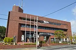
 Kikugawa City Hall | |
 Flag  Emblem | |
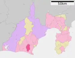
 Location of Kikugawa in Shizuoka Prefecture | |
 Kikugawa | |
| Coordinates: 34°45′N 138°5′E / 34.750°N 138.083°E | |
| Country | Japan |
| Region | Chūbu (Tōkai) |
| Prefecture | Shizuoka |
| Government | |
| • Mayor | Junichi Ota (since January 2005, and former Kikugawa leader since January 1997) |
| Area | |
| • Total | 94.19 km2 (36.37 sq mi) |
| Population (July 2019) | |
| • Total | 48,484 |
| • Density | 510/km2 (1,300/sq mi) |
| Time zone | UTC+9 (Japan Standard Time) |
| Phone number | 0537-35-2111 |
| Address | Horinouchi-61, Kikugawa-shi, Shizuoka-ken 439-8650 |
| Climate | Cfa |
| Website | Official website |
| Symbols | |
| Bird | Grey wagtail |
| Flower | Chrysanthemum |
| Tree | Camellia sinensis |
Kikugawa (菊川市, Kikugawa-shi) is a city located in the western portion of Shizuoka Prefecture, Japan. As of 28 February 2023, the city had an estimated population of 47,714 in 18,775 households,[1] and a population density of 510 persons per km². The total area of the city is 94.19 square kilometres (36.37 sq mi). The city is known for production of green tea. The city's slogan is "Green for the Next Generation".
Geography
Kikugawa is situated on the Makinohara Plateau of east-central Shizuoka. The Kikugawa River flows through the city. The area enjoys a warm maritime climate with hot, humid summers and mild, cool winters, and is subject to frequent fogs.
Surrounding Municipalities
Shizuoka Prefecture
Demographics
Per Japanese census data,[2] the population of Kikugawa has been relatively steady over the past 30 years.
| Year | Pop. | ±% |
|---|---|---|
| 1940 | 29,899 | — |
| 1950 | 37,537 | +25.5% |
| 1960 | 36,941 | −1.6% |
| 1970 | 35,365 | −4.3% |
| 1980 | 38,081 | +7.7% |
| 1990 | 43,762 | +14.9% |
| 2000 | 47,036 | +7.5% |
| 2010 | 47,035 | −0.0% |
Climate
The city has a climate characterized by hot and humid summers, and relatively mild winters (Köppen climate classification Cfa). The average annual temperature in Kikugawa is 15.1 °C (59.2 °F). The average annual rainfall is 2,192.5 mm (86.32 in) with September as the wettest month. The temperatures are highest on average in August, at around 25.7 °C (78.3 °F), and lowest in January, at around 4.7 °C (40.5 °F).[3]
| Climate data for Kikugawa (1991−2020 normals, extremes 1978−present) | |||||||||||||
|---|---|---|---|---|---|---|---|---|---|---|---|---|---|
| Month | Jan | Feb | Mar | Apr | May | Jun | Jul | Aug | Sep | Oct | Nov | Dec | Year |
| Record high °C (°F) | 17.4 (63.3) |
21.4 (70.5) |
24.4 (75.9) |
28.3 (82.9) |
30.8 (87.4) |
34.8 (94.6) |
36.9 (98.4) |
37.4 (99.3) |
35.1 (95.2) |
31.2 (88.2) |
25.9 (78.6) |
21.5 (70.7) |
37.4 (99.3) |
| Mean daily maximum °C (°F) | 9.8 (49.6) |
10.9 (51.6) |
14.0 (57.2) |
18.7 (65.7) |
22.6 (72.7) |
25.2 (77.4) |
28.9 (84.0) |
30.1 (86.2) |
26.8 (80.2) |
22.0 (71.6) |
17.2 (63.0) |
12.0 (53.6) |
19.8 (67.7) |
| Daily mean °C (°F) | 4.7 (40.5) |
5.5 (41.9) |
8.7 (47.7) |
13.5 (56.3) |
17.7 (63.9) |
20.9 (69.6) |
24.6 (76.3) |
25.7 (78.3) |
22.7 (72.9) |
17.8 (64.0) |
12.5 (54.5) |
7.1 (44.8) |
15.1 (59.2) |
| Mean daily minimum °C (°F) | 0.5 (32.9) |
0.9 (33.6) |
4.1 (39.4) |
8.9 (48.0) |
13.6 (56.5) |
17.7 (63.9) |
21.7 (71.1) |
22.7 (72.9) |
19.7 (67.5) |
14.5 (58.1) |
8.6 (47.5) |
2.9 (37.2) |
11.3 (52.4) |
| Record low °C (°F) | −5.9 (21.4) |
−7.5 (18.5) |
−4.7 (23.5) |
−1.4 (29.5) |
4.8 (40.6) |
10.6 (51.1) |
15.0 (59.0) |
17.7 (63.9) |
11.6 (52.9) |
4.4 (39.9) |
−0.7 (30.7) |
−5.4 (22.3) |
−7.5 (18.5) |
| Average precipitation mm (inches) | 71.3 (2.81) |
96.3 (3.79) |
176.5 (6.95) |
210.1 (8.27) |
207.1 (8.15) |
270.4 (10.65) |
266.5 (10.49) |
181.0 (7.13) |
272.8 (10.74) |
241.1 (9.49) |
126.4 (4.98) |
73.2 (2.88) |
2,192.5 (86.32) |
| Average precipitation days (≥ 1.0 mm) | 5.8 | 6.5 | 10.2 | 10.3 | 10.6 | 13.0 | 12.1 | 9.5 | 12.2 | 10.4 | 7.5 | 6.1 | 114.2 |
| Mean monthly sunshine hours | 209.3 | 188.5 | 194.5 | 198.0 | 195.5 | 136.6 | 167.3 | 216.6 | 158.8 | 162.7 | 175.4 | 201.8 | 2,209.6 |
| Source: Japan Meteorological Agency[4][3] | |||||||||||||
History
With the establishment of the modern municipalities system of the early Meiji period on April 1, 1889, the area around modern Kikugawa was consolidated into eleven villages within Kitō District, Shizuoka Prefecture from 38 hamlets within former Tōtōmi Province. Kikugawa Station on the Tōkaidō Main Line train between Shizuoka and Hamamatsu opened on April 16, 1889 leading to an influx of population and development. Kitō District merged with neighboring Sano District to form Ogasa District, Shizuoka in 1896. Through the Taishō and Shōwa periods, Kikugawa developed as a center of green tea production and the tea trade. Kikugawa Town was created on January 1, 1954 through the merger of former Horinouchi Town with four surrounding villages.
The modern city of Kikugawa was established on January 17, 2005, from the merger of the former town of Kikugawa, absorbing the town of Ogasa (both from Ogasa District).
Government
Kikugawa has a mayor-council form of government with a directly elected mayor and a unicameral city legislature of 17 members. The city contributes one member to the Shizuoka Prefectural Assembly.
Economy
The economy of Kikugawa is primarily agricultural, with major crops including green tea, lettuce, blueberries, cantelope and aloe. Light industries include agricultural equipment manufacturing and automobile components manufacturing.
Education
Kikugawa has nine public elementary schools and three public junior high schools operated by the city government, and one public high school operated by the Shizuoka Prefectural Board of Education. The city also have one private junior high school and two private high schools. The prefecture also operates a vocational school, the Shizuoka Prefectural Agriculture and Forestry College.
Kikugawa has three international schools:
- Colégio Nippo-Objetivo de Kikugawa (Centro de Ensino Nippo-Brasileiro) - Brazilian primary school[5]
- Centro Educacional Sorriso de Criança - Brazilian primary school[5]
- Escola Brasileira Sol Nascente - Brazilian primary school[5]
Transportation
Railway
Highway
 Tōmei Expressway Kikugawa Interchange
 National Route 473
Local attractions
- Kuroda Daikan Yashiki, an Important Cultural Property
- Kikugawa fortification ruins, a group of Sengoku-period ruins, National Historic Site
Notable people from Kikugawa
- Yū Koyama - manga artist
- Kaduya Shinba - politician
- Miuna Saito - pop singer
References
- ↑ Kikugawa City official statistics (in Japanese)
- ↑ Kikugawa population statistics
- 1 2 気象庁 / 平年値(年・月ごとの値). JMA. Retrieved April 12, 2022.
- ↑ 観測史上1~10位の値(年間を通じての値). JMA. Retrieved April 12, 2022.
- 1 2 3 "Escolas Brasileiras Homologadas no Japão" (Archive). Embassy of Brazil in Tokyo. Retrieved on October 13, 2015.
External links
- Kikugawa City official website (in Japanese)