| Lašva Лашва | |
|---|---|
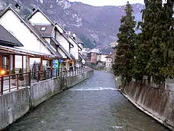 The Lašva in Travnik | |
| Location | |
| Country | Bosnia and Herzegovina |
| Physical characteristics | |
| Source | |
| • location | Karaulska Lašva and Komarska Lašva |
| • coordinates | 44°13′59″N 17°27′22″E / 44.233122662467295°N 17.456129737760445°E |
| Mouth | |
• location | river Bosna, near Zenica |
• coordinates | 44°08′20″N 17°55′56″E / 44.1390°N 17.9323°E |
| Length | 56.6 km (35.2 mi) [1] |
| Basin size | 958.1 km2 (369.9 sq mi) [1] |
| Basin features | |
| Progression | Bosna→ Sava→ Danube→ Black Sea |
The Lašva (Serbian Cyrillic: Лашва) is a river in Central Bosnia, Bosnia and Herzegovina. It is a left tributary of the Bosna.[2][3][4][5]
It originates from the confluence of two "little Lašvas", Karaulska Lašva and Komarska Lašva in Turbe. The Lašva flows through Travnik, then through Vitez before draining into the Bosna.
See also
Wikimedia Commons has media related to Lašva_River.
References
- 1 2 "Sava River Basin Analysis Report" (PDF). International Sava River Basin Commission. September 2009. p. 13. Archived from the original (PDF, 9.98 MB) on 2010-07-17.
- ↑ "Home". kartabih.com.
- ↑ Vojnogeografski institut, Ed. (1955): Travnik (List karte 1:100.000, Izohipse na 20 m). Vojnogeografski institut, Beograd / Military Geographical Institute, Ed. (1955): Travnik (map sheet 1: 100,000, Contour lines at 20 m). Military Geographical Institute, Belgrade.
- ↑ Spahić M. et al. (2000): Bosna i Hercegovina (1:250.000). Izdavačko preduzeće „Sejtarija", Sarajevo., The Map
- ↑ Mučibabić B., Ed. (1998): Geografski atlas Bosne i Hercegovine. Geodetski zavod BiH, Sarajevo, ISBN 9958-766-00-0., pp: 4-5.
This article is issued from Wikipedia. The text is licensed under Creative Commons - Attribution - Sharealike. Additional terms may apply for the media files.