| Lake Miyagase 宮ヶ瀬湖 | |
|---|---|
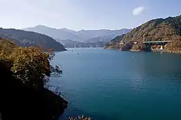 | |
 Lake Miyagase 宮ヶ瀬湖 | |
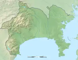
| Location | Aiko District, Kanagawa |
| Coordinates | 35°31′46″N 139°13′44″E / 35.52953°N 139.229°E |
| Type | reservoir |
| Primary inflows | Nakatsu River, Hayata River |
| Primary outflows | Nakatsu River |
| Basin countries | Japan |
| Max. length | 5.68 km (3.53 mi) |
| Max. width | 1.07 km (0.66 mi) |
| Surface area | 4.60 km2 (1.78 sq mi) |
| Water volume | 0.193 km3 (156,000 acre⋅ft) |
| Settlements | Aikawa, Kanagawa |
Lake Miyagase (宮ヶ瀬湖) is a lake within the Aiko District of Kanagawa, Japan, located between Sagamihara and Atsugi. The lake offers views of Tanzawa Mountains, including Mount Hiru. The lake is a man-made reservoir and formed by the Miyagase Dam, and is a source of drinking water for Yokohama and Tokyo.
External links
 Media related to Lake Miyagase at Wikimedia Commons
This article is issued from Wikipedia. The text is licensed under Creative Commons - Attribution - Sharealike. Additional terms may apply for the media files.