
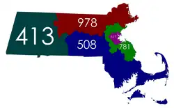
Numbering plan areas and area codes since May 2001
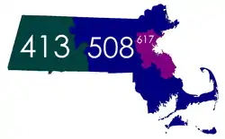
September 1997 – May 2001
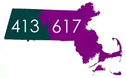
July 1988 – September 1997
October 1947 – July 1988
Massachusetts is divided into five distinct numbering plan areas (NPAs), which are served by nine area codes in the North American Numbering Plan (NANP), organized as four overlay complexes and a single-area code NPA.
Eastern Massachusetts has area codes 339, 351, 508, 617, 774, 781, 857, and 978.[1] Western Massachusetts has area code 413.[1]
The numbering plan areas are organized into two local access and transport areas (LATAs): 126 comprises the western part, and 128 covers the central and eastern parts.[2]
| Area code | Region |
|---|---|
| 339/781 | Canton, Hanson, Lincoln, Nahant, Plympton, Revere, Stoughton, Winchester and east-central Massachusetts |
| 351/978 | Ashby, Barre, Boxborough, Carlisle, Groveland, Rowley, Wendell, Wenham and northeastern Massachusetts |
| 413 | Becket, Cummington, Hancock, Monson, Montague, Savoy, Sheffield, Warren and western Massachusetts |
| 508/774 | Berkley, Dennis, Douglas, Easton, Edgartown, Oakham, Oxford, Upton and southeastern Massachusetts |
| 617/857 | Belmont, Brookline, Chelsea, Everett, Milton, Quincy, Watertown, Winthrop and close-in Boston suburbs |
See also
References
- 1 2 Staff writer (2022). "Massachusetts Area Code Information". areacodehelp.com. Retrieved January 12, 2023.
- ↑ "Northeast LATA Boundaries (Archived copy)" (PDF). Archived from the original (PDF) on 2016-04-09. Retrieved 2017-09-24.
External links
 Media related to Area code maps of Massachusetts at Wikimedia Commons
- Detailed map of Massachusetts area codes (pdf)
- NANPA area code map of Massachusetts
This article is issued from Wikipedia. The text is licensed under Creative Commons - Attribution - Sharealike. Additional terms may apply for the media files.