This is a list of named craters on 253 Mathilde, an asteroid of the asteroid belt, approximately 53 kilometers in diameter. Because Mathilde is a dark, carbonaceous body, all of its craters have been named after famous coalfields from across the world.[1][2] As of 2017, there are 23 officially named craters on this asteroid.[3]

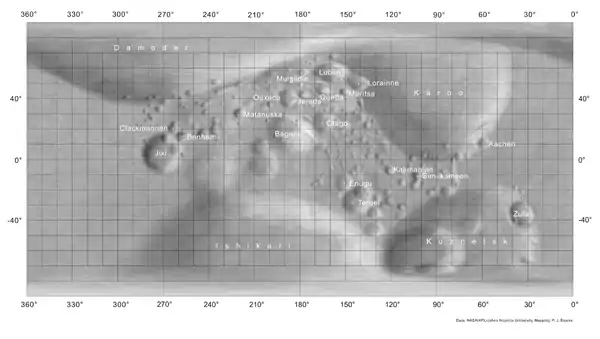
Map of Mathilde and its geological features[2]

List

CraterCoordinatesDiameter
(km)
Approval
Year
EponymRef
Aachen9°12′N 60°54′W / 9.2°N 60.9°W / 9.2; -60.9 (Aachen)4.82000German coal basinWGPSN
Baganur14°36′N 168°24′E / 14.6°N 168.4°E / 14.6; 168.4 (Baganur)16.42000Mongolian coal basinWGPSN
Benham19°00′N 112°48′E / 19°N 112.8°E / 19; 112.8 (Benham)2.22000Coal mine in Kentucky USAWGPSN
Clackmannan18°54′N 99°12′E / 18.9°N 99.2°E / 18.9; 99.2 (Clackmannan)2.82000Scottish coal basinWGPSN
Damodar73°00′N 96°12′E / 73°N 96.2°E / 73; 96.2 (Damodar)28.72000Largest Indian coal basinWGPSN
Enugu15°18′S 151°36′W / 15.3°S 151.6°W / -15.3; -151.6 (Enugu)5.92000Nigerian coal fieldWGPSN
Ishikari66°12′S 173°06′E / 66.2°S 173.1°E / -66.2; 173.1 (Ishikari)29.32000Largest Japanese coal fieldWGPSN
Jerada42°06′N 177°18′W / 42.1°N 177.3°W / 42.1; -177.3 (Jerada)2.52000Largest Moroccan coal basinWGPSN
Jixi12°18′S 103°30′E / 12.3°S 103.5°E / -12.3; 103.5 (Jixi)19.92000Chinese coal basinWGPSN
Kalimantan7°42′S 123°42′W / 7.7°S 123.7°W / -7.7; -123.7 (Kalimantan)2.72000Coal field on Borneo IndonesiaWGPSN
Karoo33°30′N 98°24′W / 33.5°N 98.4°W / 33.5; -98.4 (Karoo)33.42000South African coal basinWGPSN
Kuznetsk45°54′S 88°54′W / 45.9°S 88.9°W / -45.9; -88.9 (Kuznetsk)28.52000Russian coal basinWGPSN
Lorraine48°06′N 142°30′W / 48.1°N 142.5°W / 48.1; -142.5 (Lorraine)4.12000Largest French coal basinWGPSN
Lublin55°18′N 156°48′W / 55.3°N 156.8°W / 55.3; -156.8 (Lublin)6.52000Polish coal basinWGPSN
Maritsa44°36′N 151°30′W / 44.6°N 151.5°W / 44.6; -151.5 (Maritsa)2.42000Bulgarian coal fieldWGPSN
Matanuska27°18′N 142°42′E / 27.3°N 142.7°E / 27.3; 142.7 (Matanuska)2.92000Coal field in Alaska USAWGPSN
Mulgildie57°42′N 176°06′W / 57.7°N 176.1°W / 57.7; -176.1 (Mulgildie)2.52000Australian coal basinWGPSN
Oaxaca38°42′N 173°42′E / 38.7°N 173.7°E / 38.7; 173.7 (Oaxaca)5.22000Mexican coal fieldsWGPSN
Otago23°42′N 164°30′W / 23.7°N 164.5°W / 23.7; -164.5 (Otago)7.92000Largest New Zealand coal fieldWGPSN
Quetta45°36′N 165°30′W / 45.6°N 165.5°W / 45.6; -165.5 (Quetta)3.22000Pakistani coal fieldWGPSN
Similkameen13°30′S 104°42′W / 13.5°S 104.7°W / -13.5; -104.7 (Similkameen)3.42000Canadian coal fieldWGPSN
Teruel28°06′S 142°42′W / 28.1°S 142.7°W / -28.1; -142.7 (Teruel)7.62000Spanish coal fieldWGPSN
Zulia39°30′S 30°54′W / 39.5°S 30.9°W / -39.5; -30.9 (Zulia)12.32000Principal state in Venezuela in which coal is minedWGPSN

See also

References

  1. "Categories for Naming Features on Planets and Satellites". US Geological Survey. Gazetteer of Planetary Nomenclature – International Astronomical Union (IAU) Working Group for Planetary System Nomenclature (WGPSN). Retrieved 14 August 2017.
  2. 1 2 "IAU – Gazetteer of Planetary Nomenclature – Mathilde". US Geological Survey. Retrieved 14 August 2017.
  3. "Nomenclature Search Results: Mathilde > Crater, Craters". US Geological Survey. Gazetteer of Planetary Nomenclature – International Astronomical Union (IAU) Working Group for Planetary System Nomenclature (WGPSN). Retrieved 14 August 2017.
This article is issued from Wikipedia. The text is licensed under Creative Commons - Attribution - Sharealike. Additional terms may apply for the media files.