Mantong | |
|---|---|
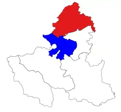
 Location in Palaung SAZ and Kyaukme district (in red) | |
 Mantong | |
| Coordinates: 23°15′0″N 97°7′0″E / 23.25000°N 97.11667°E | |
| Country | |
| State | |
| Self-administered zone | |
| Area | |
| • Total | 975.75 sq mi (2,527.18 km2) |
| Elevation | 4,121 ft (1,256 m) |
| Population (2019)[2] | 35,916 |
| • Ethnicities | |
| • Religions | Buddhism |
| Time zone | UTC+6:30 (MMT) |
Mantong Township ((Burmese: မန်တုံမြို့နယ်); also known as Manton Township and Mantung Township) is a township of the Pa Laung Self-Administered Zone[3] in the Shan State of eastern Burma (Myanmar). The principal town and administrative seat is Mantong (Manton).
Prior to August 2010, Kyaukme District included both Mantong Township and Namhsan Township; and both of them were transferred that month to the newly created Pa Laung Self-Administered Zone.[3][4]
It was reported that the town was captured by the Ta’ang National Liberation Army on 23 December 2023[5]
References
- ↑ GoogleEarth
- ↑ Myanmar Information Management Unit (September 2019). Manton Myone Daethasaingyarachatlatmya မန်တုံမြို့နယ် ဒေသဆိုင်ရာအချက်လက်များ [Mantong Township Regional Information] (PDF) (Report). MIMU. Retrieved 17 October 2023.
- 1 2 "The Union of Myanmar, The State Peace and Development Council, Notification No. 33/2010, 20 August 2010" English translation
- ↑ "Map of Shan State" Myanmar's NET, showing district boundaries, last accessed 21 November 2010
- ↑ "Deadly Junta Shelling Forces Mass Exodus From Myanmar's Historic Mrauk-U, Rakhine". Irrawaddy. 25 December 2023.
This article is issued from Wikipedia. The text is licensed under Creative Commons - Attribution - Sharealike. Additional terms may apply for the media files.

