U.S. Route 1 | ||||
|---|---|---|---|---|
| Route information | ||||
| Maintained by CTDOT | ||||
| Length | 117.37 mi[1] (188.89 km) | |||
| Existed | 1926–present | |||
| Major junctions | ||||
| South end | ||||
Milford Parkway in Milford | ||||
| North end | ||||
| Location | ||||
| Country | United States | |||
| State | Connecticut | |||
| Counties | Fairfield, New Haven, Middlesex, New London | |||
| Highway system | ||||
| ||||
| ||||

U.S. Route 1 (US 1) in the U.S. state of Connecticut is a major east–west U.S. Route along Long Island Sound. It has been replaced by Interstate 95 (I-95) as a through route, which it closely parallels, and now primarily serves as a local business route. Despite its largely east–west orientation, it is part of a north–south route and is mostly signed north–south.
Most of US 1 through Connecticut encompasses its predecessor, the Boston Post Road, and, in many towns, it is still named Boston Post Road (or Post Road).
Route description
US 1 in Connecticut largely parallels I-95 and has many interchanges with it. The route passes through each city and town of Connecticut bordering the Long Island Sound (in addition to the town of Orange).
From Greenwich to Branford, US 1 is mostly a four- or six-lane principal arterial road (with some two-lane sections in dense areas). From Branford to Stonington, US 1 it a two- or four-lane minor arterial road.
US 1 is known as Boston Post Road or Post Road for the majority of its length, but it also encompasses other local street names. The route is known as Putnam Avenue in Greenwich; Tresser Boulevard, West Main Street, and East Main Street in Stamford; Connecticut Avenue in parts of Norwalk; Boston Avenue in parts of Bridgeport; and New London Road in parts of Groton. In Stonington, the route is known as Stonington Road, South Broad Street, and West Broad Street. US 1 is also known as Main Street in Branford and Clinton.
Overlap with I-95
US 1 is concurrent with I-95 in two sections, both of which are river crossings. The western concurrency is between exits 68 and 70 from Old Saybrook to Old Lyme, where the two routes cross the Connecticut River via the Raymond E. Baldwin Bridge. The eastern concurrency is between exits 83 and 85 from New London to Groton, where the routes cross the Thames River via the Gold Star Memorial Bridge.
US 1's two other major bridge crossings closely parallel the I-95 crossings of those rivers. The Washington Bridge over the Housatonic River, connecting Milford and Stratford, as well as the Tomlinson Lift Bridge over the Quinnipiac River in New Haven, are a short distance away from I-95's Moses Wheeler and Pearl Harbor Memorial bridges, respectively.
US 1 also forms a frontage road for I-95 in parts of Fairfield, Stratford, and New London.
History
US 1 generally follows the old Boston Post Road and turnpike roads built to replace it. Specifically, the Greenwich Road, chartered in 1792, was the part in Greenwich and became part of the longer New York-to-Fairfield Connecticut Turnpike (not to be confused with the contemporary Connecticut Turnpike) in 1806. The New Haven and Milford Turnpike (1802) continued from Milford to New Haven, and the New London and Lyme Turnpike (1807) connected Old Lyme with New London.
Route 51
Route 51 | |
|---|---|
| Location | Old Lyme to East Lyme |
| Length | 9.4 mi (15.1 km) |
| Existed | 1962–1976 |
US 1 was originally built where it currently exists in Old Lyme and East Lyme. However, from 1949 to 1976, US 1 existed where I-95 currently exists in Old Lyme and East Lyme. From 1962 to 1976, this stretch of road was Route 51, which traveled for 9.4 miles (15.1 km) through Old Lyme and East Lyme and was known as the Boston Post Road. In 1976, US 1 returned to the 9.4-mile (15.1 km) stretch of road, thus eliminating the need for Route 51.
Major intersections
| County | Location | mi[1] | km | Destinations | Notes |
|---|---|---|---|---|---|
| Byram River | 0.00 | 0.00 | Continuation into New York | ||
| New York–Connecticut state line | |||||
| Fairfield | Riverside | 4.83 | 7.77 | Exit 5 on I-95 (Connecticut Turnpike) | |
| Stamford | 6.93 | 11.15 | |||
| 8.60 | 13.84 | Southern terminus of Route 106 | |||
| 8.66 | 13.94 | Exit 9 on I-95 (Connecticut Turnpike) | |||
| Community of Darien | 11.17 | 17.98 | Exit 11 on I-95 (Connecticut Turnpike); southbound entrance is via Ledge Road | ||
| 11.56 | 18.60 | Western terminus of Route 136 | |||
| 11.66 | 18.76 | Southern terminus of Route 124 | |||
| Town of Darien | 12.51– 12.87 | 20.13– 20.71 | Exit 13 on I-95 (Connecticut Turnpike); northbound entrance is via Old Kings Highway | ||
| Norwalk | 14.24 | 22.92 | Exit 14 on I-95 (Connecticut Turnpike); northbound entrance is via Scribner Avenue | ||
| 15.73 | 25.31 | Exit 1 on US 7 | |||
| 16.17 | 26.02 | Southern terminus of Route 123 | |||
| 16.54 | 26.62 | Southern terminus of Route 53 | |||
| Community of Westport | 19.22 | 30.93 | |||
| 19.83 | 31.91 | ||||
| Town of Westport | 20.80 | 33.47 | Sherwood Island Connector (SSR 476) – Sherwood Island State Park | ||
| Southport | 23.31 | 37.51 | Exit 19 on I-95 (Connecticut Turnpike); Access via local roads except northbound entrance | ||
| Fairfield | 25.51 | 41.05 | Southern terminus of Route 135 | ||
| 25.83 | 41.57 | Western terminus of Route 130 | |||
| 26.23– 26.47 | 42.21– 42.60 | Exit 23 on I-95 (Connecticut Turnpike) | |||
| 27.16 | 43.71 | Exit 24 on I-95 (Connecticut Turnpike); Access to I-95 south via local roads | |||
| 28.15 | 45.30 | Southern terminus of Route 58 | |||
| Bridgeport | 28.68 | 46.16 | Southern terminus of Route 59 | ||
| 30.16 | 48.54 | Access via Chopsey Hill Road | |||
| 31.43 | 50.58 | Southern terminus of Route 127 | |||
| Community of Stratford | 34.03 | 54.77 | Southern terminus of Route 108 | ||
| 34.20 | 55.04 | ||||
| 34.86 | 56.10 | Eastern terminus of Route 130 | |||
| 34.91– 35.09 | 56.18– 56.47 | Exit 33 on I-95 (Connecticut Turnpike) | |||
| 35.06 | 56.42 | Southern terminus of Route 110 | |||
| Housatonic River | 35.27– 35.43 | 56.76– 57.02 | Washington Bridge | ||
| New Haven | Milford | 36.31 | 58.44 | Exit 34 on I-95 (Connecticut Turnpike) | |
| 37.33 | 60.08 | Western terminus of Route 162 | |||
| 38.91 | 62.62 | Access via Milford Parkway | |||
| 39.20 | 63.09 | Southern terminus of Route 121 | |||
| 40.01 | 64.39 | Exits 39A-B on I-95 (Connecticut Turnpike) | |||
| Orange | 42.25 | 67.99 | Southern terminus of Route 152 | ||
| 43.20 | 69.52 | Southern terminus of Route 114 | |||
| 43.95 | 70.73 | Eastern terminus of Route 162 | |||
| West Haven | 46.06 | 74.13 | |||
| New Haven | 46.64 | 75.06 | |||
| 48.25– 48.81 | 77.65– 78.55 | Access via Water Street to Route 34 (Oak Street Connector) | |||
| 49.23– 49.41 | 79.23– 79.52 | Tomlinson Lift Bridge over the Quinnipiac River | |||
| 50.25 | 80.87 | To Tweed-New Haven Airport | |||
| East Haven | 50.65– 51.23 | 81.51– 82.45 | Exit 51 on I-95 (Connecticut Turnpike) | ||
| 51.79 | 83.35 | Western terminus of Route 142 | |||
| 52.06 | 83.78 | Southern terminus of Route 100 | |||
| Branford | 53.85 | 86.66 | Eastern terminus of Route 142 | ||
| 53.96 | 86.84 | Exit 53 on I-95 north (Connecticut Turnpike); Access via Branford Connector | |||
| 54.06 | 87.00 | Western terminus of Route 146 | |||
| 56.82 | 91.44 | Exit 55 on I-95 (Connecticut Turnpike) | |||
| 57.06 | 91.83 | Southern terminus of Route 139 | |||
| Guilford | 59.21 | 95.29 | Eastern terminus of Route 22 | ||
| 61.76 | 99.39 | Exit 57 on I-95 (Connecticut Turnpike) | |||
| 63.07 | 101.50 | ||||
| 64.35 | 103.56 | Eastern terminus of Route 146 | |||
| Madison | 67.85 | 109.19 | |||
| Middlesex | Clinton | 71.67 | 115.34 | ||
| 72.52 | 116.71 | ||||
| Westbrook | 76.25 | 122.71 | |||
| Old Saybrook | 78.19 | 125.83 | |||
| 79.52 | 127.98 | Southern terminus of Route 154 | |||
| 80.52 | 129.58 | Southern terminus of Route 154 concurrency | |||
| 80.95 | 130.28 | Northern terminus of Route 154 concurrency | |||
| 81.98 | 131.93 | Southern terminus I-95 concurrency; Exit 68 on I-95 south (Connecticut Turnpike) | |||
| Exit 69; southern terminus of Route 9 | |||||
| Connecticut River | 82.15– 82.63 | 132.21– 132.98 | Raymond E. Baldwin Bridge | ||
| New London | Old Lyme | 82.86– 83.34 | 133.35– 134.12 | Northern terminus of I-95 concurrency; Exit 70 on I-95 (Connecticut Turnpike) southern terminus of Route 156 concurrency | |
| 83.53 | 134.43 | Northern terminus of Route 156 concurrency | |||
| East Lyme | 92.46 | 148.80 | |||
| 92.97 | 149.62 | Exit 75 on I-95 (Connecticut Turnpike) | |||
| Waterford | 97.36 | 156.69 | Eastern terminus of Route 156 | ||
| New London | 98.70 | 158.84 | Northern terminus of Route 213 | ||
| 99.99 | 160.92 | Southern terminus of Route 85 | |||
| 100.89 | 162.37 | Exit 84N on I-95; US 1 acts as frontage roads for I-95 | |||
| 101.03 | 162.59 | Southern terminus of I-95 concurrency; Exit 83 on I-95 | |||
| Thames River | 101.17– 102.26 | 162.82– 164.57 | Gold Star Memorial Bridge | ||
| Groton | 102.21– 102.95 | 164.49– 165.68 | Northern terminus of I-95 concurrency; Exit 85 on I-95; southern terminus of Route 12 | ||
| 103.22 | 166.12 | ||||
| 105.55 | 169.87 | Southern terminus of Route 117 | |||
| 106.47 | 171.35 | Western terminus of Route 215 | |||
| 108.98 | 175.39 | Eastern terminus of Route 215 | |||
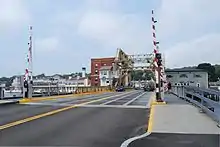
| Mystic River | 109.12 | 175.61 | Mystic River Bascule Bridge | ||
| Stonington | 109.67 | 176.50 | Southern terminus of Route 27 | ||
| 112.48 | 181.02 | Southern terminus of US 1A | |||
| 113.63 | 182.87 | Northern terminus of US 1A | |||
| 116.78 | 187.94 | Eastern terminus of Route 234 | |||
| 117.24 | 188.68 | Eastern terminus of Route 2 | |||
| Pawcatuck River | 117.37 | 188.89 | Connecticut–Rhode Island state line | ||
| Bridge; continuation into Rhode Island | |||||
1.000 mi = 1.609 km; 1.000 km = 0.621 mi
| |||||
References
- 1 2 Connecticut Department of Transportation, "Highway Log" (PDF). (1.80 MiB) as of December 31, 2014