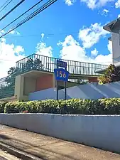
Highway 156 | |||||||||
|---|---|---|---|---|---|---|---|---|---|
| Ruta 156 | |||||||||
| Route information | |||||||||
| Maintained by Puerto Rico DTPW | |||||||||
| Length | 58.7 km[1] (36.5 mi) | ||||||||
| Existed | 1953[2]–present | ||||||||
| Major junctions | |||||||||
| West end | |||||||||
| |||||||||
| East end | |||||||||
| Location | |||||||||
| Country | United States | ||||||||
| Territory | Puerto Rico | ||||||||
| Municipalities | Orocovis, Barranquitas, Comerío, Aguas Buenas, Caguas | ||||||||
| Highway system | |||||||||
| |||||||||
| |||||||||


Puerto Rico Highway 156 (PR-156) is a long east–west highway which connects Caguas to Orocovis, passing through Aguas Buenas, Comerío and Barranquitas. This route extends from its junction with PR-1 in downtown Caguas to PR-5155 in downtown Orocovis.[3][4]
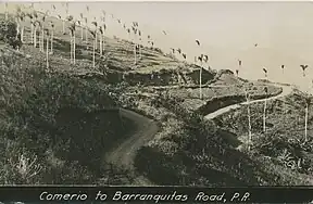 Comerío to Barranquitas Road (currently PR-156)
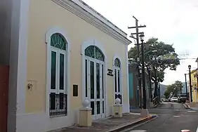 Calle Betances (PR-156) in Caguas barrio-pueblo
Route description
It is the main artery to Aguas Buenas from Caguas since the highway from Puerto Rico Highway 52 to the main downtown has at least two lanes and a shoulder per direction. From Aguas Buenas to Orocovis it is a rural, yet safe road which enters all the business districts and plazas of Aguas Buenas, Comerío, Barranquitas and Orocovis. It is one of two long east–west highways through the center of the island (the other being Puerto Rico Highway 111) but it never approaches a coast. Puerto Rico Highway 111 approaches Aguadilla's shore near PR-2 but PR-156, ending in Caguas, is nearly 35 kilometers away from the east coast.[3][4]
 PR-156 west in Barranquitas barrio-pueblo
.jpg.webp) Río Hondo Bridge in Comerío
Río Hondo Bridge in Comerío
Major intersections
 PR-719 north approaching PR-156 junction in downtown Barranquitas
 Signs for PR-156 at the southern terminus of PR-152 in Barranquitas
.jpg.webp) PR-156 east at PR-167 and PR-7167 intersection in Doña Elena, Comerío
PR-156 east at PR-167 and PR-7167 intersection in Doña Elena, Comerío
| Municipality | Location | km[1] | mi | Destinations | Notes |
|---|---|---|---|---|---|
| Orocovis | Orocovis barrio-pueblo–Orocovis line | 0.0 | 0.0 | Western terminus of PR-156 | |
| 0.4 | 0.25 | ||||
| Botijas | 3.1 | 1.9 | |||
| 6.4– 6.5 | 4.0– 4.0 | ||||
| Barranquitas | Palo Hincado | 10.5 | 6.5 | ||
| 11.6 | 7.2 | ||||
| Barranquitas barrio-pueblo | 14.2– 14.3 | 8.8– 8.9 | |||
| 15.4– 15.5 | 9.6– 9.6 | One-way street; southbound access via Calle Susano Maldonado | |||
| 15.9 | 9.9 | ||||
| Barranquitas barrio-pueblo–Quebradillas line | 16.4 | 10.2 | |||
| Quebrada Grande–Honduras line | 20.4 | 12.7 | |||
| 22.4 | 13.9 | ||||
| Comerío | Río Hondo | 26.4 | 16.4 | ||
| 28.6– 28.7 | 17.8– 17.8 | ||||
| 28.7 | 17.8 | Puente del Río Hondo over the Río Hondo[5] | |||
| Comerío barrio-pueblo | 31.7– 31.8 | 19.7– 19.8 | |||
| 32.2 | 20.0 | ||||
| Palomas–Comerío barrio-pueblo line | 32.5 | 20.2 | |||
| Quebrada Higüero | 34.5 | 21.4 | Puente del Higüero[5] | ||
| Doña Elena | 35.1 | 21.8 | |||
| Naranjo | 35.2– 35.3 | 21.9– 21.9 | |||
| 35.5– 35.6 | 22.1– 22.1 | ||||
| 36.5 | 22.7 | ||||
| Comerío–Aguas Buenas municipal line | Naranjo–Bayamoncito line | 39.9 | 24.8 | ||
| Aguas Buenas | Bayamoncito | 41.3 | 25.7 | ||
| Mula–Sumidero line | 47.6 | 29.6 | Western terminus of PR-173 concurrency | ||
| Aguas Buenas barrio-pueblo | 50.0 | 31.1 | |||
| 50.3 | 31.3 | Eastern terminus of PR-173 concurrency; one-way street | |||
| Bairoa–Sumidero– Cagüitas tripoint | 50.6– 50.7 | 31.4– 31.5 | Seagull intersection | ||
| Bairoa | 52.3 | 32.5 | |||
| Caguas | Cañabón | 53.6 | 33.3 | ||
| 55.4– 55.5 | 34.4– 34.5 | ||||
| 57.1 | 35.5 | ||||
| Caguas barrio-pueblo | 57.8– 57.9 | 35.9– 36.0 | PR-52 exit 19; partial cloverleaf interchange | ||
| 58.4 | 36.3 | ||||
| 58.6 | 36.4 | One-way street | |||
| 58.7 | 36.5 | Eastern terminus of PR-156; one-way street | |||
1.000 mi = 1.609 km; 1.000 km = 0.621 mi
| |||||
Related routes
Currently, Puerto Rico Highway 156 has two branches along its route. One of them is located in Orocovis and the other is between Aguas Buenas and Caguas.
Puerto Rico Highway 5156
Highway 5156 | |
|---|---|
| Location | Orocovis |
| Length | 0.25 km[6] (0.16 mi; 820 ft) |
Puerto Rico Highway 5156 (PR-5156) is an east–west avenue located in downtown Orocovis. This highways extends from PR-156 to PR-155, crossing the Orocovis River.[7] The entire route is located in Orocovis.
| Location | km[6] | mi | Destinations | Notes | |
|---|---|---|---|---|---|
| Orocovis barrio-pueblo | 0.25 | 0.16 | Western terminus of PR-5156 | ||
| 0.15 | 0.093 | ||||
| Orocovis barrio-pueblo–Orocovis line | 0.00 | 0.00 | Eastern terminus of PR-5156 | ||
| 1.000 mi = 1.609 km; 1.000 km = 0.621 mi | |||||
Puerto Rico Highway 7156
Highway 7156 | |
|---|---|
| Location | Aguas Buenas – Caguas |
| Length | 2.7 km[8] (1.7 mi) |
Puerto Rico Highway 7156 (PR-7156) is a rural, east–west road between the municipalities of Aguas Buenas and Caguas. This route is an old portion of PR-156 that connects the new alignment with PR-777 between Bairoa and Cagüitas barrios of Aguas Buenas. It extends from PR-156 west in Bairoa, Aguas Buenas, to PR-156 east in Cañabón, Caguas.[9][10]
| Municipality | Location | km[8] | mi | Destinations | Notes |
|---|---|---|---|---|---|
| Aguas Buenas | Bairoa | 0.0 | 0.0 | Western terminus of PR-7156 | |
| Bairoa–Cagüitas line | 1.6 | 0.99 | |||
| Caguas | Cañabón | 2.7 | 1.7 | Eastern terminus of PR-7156 | |
| 1.000 mi = 1.609 km; 1.000 km = 0.621 mi | |||||
See also
References
- 1 2 Google (24 March 2020). "PR-156" (Map). Google Maps. Google. Retrieved 24 March 2020.
- ↑ "Comerío, Memoria Núm. 41" (PDF). Puerto Rico Planning Board (in Spanish). 1955. Retrieved 4 August 2020.
- 1 2 National Geographic Maps (2011). Puerto Rico (Map). 1:125,000. Adventure Map (Book 3107). Evergreen, Colorado: National Geographic Maps. ISBN 978-1566955188. OCLC 756511572.
- 1 2 "Tránsito Promedio Diario (AADT)". Transit Data (Datos de Transito) (in Spanish). DTOP PR. pp. 84–85. Archived from the original on 1 April 2019.
- 1 2 Luis F. Pumarada O’Neill (1991). "Los Puentes Históricos de Puerto Rico" (PDF) (in Spanish). Retrieved 24 March 2020.
- 1 2 Google (16 August 2020). "PR-5156" (Map). Google Maps. Google. Retrieved 16 August 2020.
- ↑ "Plan de ordenación territorial Municipio de Orocovis" (PDF). Junta de Planificación (in Spanish). p. 83. Retrieved 7 April 2023.
- 1 2 Google (16 August 2020). "PR-7156" (Map). Google Maps. Google. Retrieved 16 August 2020.
- ↑ "Mapa de Calificación de Aguas Buenas" (PDF). Junta de Planificación (in Spanish). Retrieved 7 April 2023.
- ↑ "Aguas Buenas, Memoria Núm. 34" (PDF). Puerto Rico Planning Board (in Spanish). 1955. Retrieved 7 April 2023.
External links
 Media related to Puerto Rico Highway 156, Puerto Rico Highway 5156 and Puerto Rico Highway 7156 at Wikimedia Commons
- PR-156, Orocovis, Puerto Rico