Route 138 | ||||
|---|---|---|---|---|
| Chemin Du Roy | ||||
 | ||||
| Route information | ||||
| Maintained by Transports Québec | ||||
| Length | 1,420 km[1] (880 mi) | |||
| History | ||||
| Major junctions | ||||
| West end | ||||
| East end | ||||
| Location | ||||
| Country | Canada | |||
| Province | Quebec | |||
| Highway system | ||||
| ||||

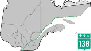
Route 138 is a major highway in the Canadian province of Quebec, following the entire north shore of the Saint Lawrence River past Montreal to the temporary eastern terminus in Kegashka on the Gulf of Saint Lawrence. The western terminus is in Elgin, at the border with New York State south-west of Montreal (connecting with New York State Route 30 at the Trout River Border Crossing). Part of this highway is known as the Chemin du Roy, or King's Highway, which is one of the oldest highways in Canada.
It passes through the Montérégie, Montreal, Lanaudière, Mauricie, Capitale-Nationale and Côte-Nord regions of Quebec. In Montreal, Highway 138 runs via Sherbrooke Street, crosses the Pierre Le Gardeur Bridge to Charlemagne and remains a four-lane road until exiting Repentigny.
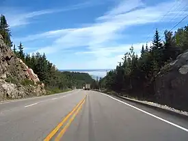
This highway takes a more scenic route than the more direct Autoroute 40 between Montreal and Quebec City. It crosses the Saguenay River via a ferry which travels between Baie-Sainte-Catherine and Tadoussac; in the event of a closure of this ferry, drivers must take a significant detour via Quebec Route 172 and Quebec Route 170 to the city of Saguenay in order to cross the river by bridge.
From Moisie River to Havre-Saint-Pierre
At the beginning of the 20th century, the first routes of what would become Route 138 (formerly Route 15) were laid in the vicinity of Sept-Îles. In 1961, a section was added from the Franquelin region to the tip of the Moisie River, some 20 kilometres east of Sept-Îles.
On the north shore of the Gulf of St. Lawrence, until 1976, there was no continuous route to go further east than the Moisie River. Only bits of paths here and there connect a few coastal villages to each other, Natashquan connects to Aguanish by a dirt road (1959).
Route 138, from Moisie River to Havre-Saint-Pierre, opened in the spring of 1976, from there access to the islands of the Mingan Archipelago by sea.
In 1984, to commemorate the 450th anniversary of Jacques Cartier's arrival in New France, the Commission de toponymie gave this name to the part of Route 138 located east of the Saguenay River, that is, the part that extends from Tadoussac to Havre-Saint-Pierre.[2]' [3]
From Havre-Saint-Pierre to Natashquan

Until the mid-1990s, the highway's eastern terminus was Havre-Saint-Pierre, but in 1996 the extension to Natashquan was completed. A 40 km gravel section between Natashquan and Kegaska opened on September 26, 2013, with the inauguration of a bridge across the Natashquan River.[4]' [5]
A second segment of about 17 km extends from Tête-à-la-Baleine's airport, east through Tête-à-la-Baleine, to the ferry terminal southeast of Tête-à-la-Baleine. There is also a 10.7 km roadway, la route Mecatina, from Mutton Bay to a ferry terminal in La Tabatière and continuing beyond.
A third segment of Route 138 extends from Old Fort to the Newfoundland and Labrador border (connecting with Newfoundland and Labrador Provincial Route 510), near Blanc-Sablon on the eastern end of the Côte-Nord.[6]
A gap remains between Kegaska and Old Fort, through isolated communities accessible only by coastal ferry. On August 25, 2006, the Quebec government announced a 10-year project to connect the two segments by building 425 km of highway along the Lower North Shore. In 2011, the Quebec government announced an additional $122 million investment for the project over five years as part of the Plan Nord.[7] However, by 2013 difficulties ensued between the Quebec Ministry of Transport and the Pakatan Corporation, who was previously responsible for managing the funding for this project, leading to the termination of agreement between the two. By this time only 12 km of this road had been built, plus some additional engineering work and deforestation.[8] The construction of two segments of the highway (Kegaska–La Romaine and Tête-à-la-Baleine–La Tabatière) was set to begin in 2019. A total of $232 million will be contributed to this project.[9]
Municipalities along Route 138
Major intersections
| RCM | Location | km[10] | mi | Exit | Destinations | Notes | |
|---|---|---|---|---|---|---|---|
| Le Haut-Saint-Laurent | Elgin | 0.0 | 0.0 | Continues into New York | |||
| Canada–United States border at Trout River Border Crossing | |||||||
| Huntingdon | 17.8 | 11.1 | West end of R-202 concurrency | ||||
| 18.1 | 11.2 | East end of R-202 concurrency | |||||
| Ormstown | 32.8 | 20.4 | West end of R-201 concurrency | ||||
| 34.0 | 21.1 | East end of R-202 concurrency | |||||
| Très-Saint-Sacrement | 51.0 | 31.7 | Northern terminus of R-203 | ||||
| Beauharnois-Salaberry | Sainte-Martine | 56.2 | 34.9 | West end of R-205 concurrency | |||
| 57.3 | 35.6 | East end of R-205 concurrency | |||||
| Roussillon | Mercier–Châteauguay boundary | 67.8 | 42.1 | A-30 exit 38; west end of R-132 concurrency | |||
| Kahnawake | 76.2 | 47.3 | – | Interchange; northern terminus of R-207 & R-221 | |||
| 77.2 | 48.0 | – | Interchange; east end of R-132 concurrency | ||||
| St. Lawrence River | 77.5– 79.1 | 48.2– 49.2 | Pont Honoré-Mercier (Honoré Mercier Bridge) | ||||
| Montréal | Montréal | 79.3 | 49.3 | 1 | Rue Airlie | Interchange; eastbound exit and westbound entrance | |
| 80.4 | 50.0 | 2 | Rue Clément, Rue St-Patrick | Interchange | |||
| 81.3 | 50.5 | 4 63 | Interchange; west end of A-20 concurrency; exit numbers follow A-20 | ||||
| 82.5 | 51.3 | 64 | Interchange; east end of A-20 concurrency; R-138 follows Rue Saint-Jacques | ||||
| 84.0 | 52.2 | Boulevard Cavendish / Rue Saint-Jacques | R-138 follows Boulevard Cavendish | ||||
| 84.1 | 52.3 | Boulevard De Maisonneuve | Interchange; westbound exit and eastbound entrance | ||||
| 84.4 | 52.4 | Rue Sherbrooke / Boulevard Cavendish | R-138 follows Rue Sherbrooke | ||||
| 86.2 | 53.6 | A-15 exit 64 | |||||
| 90.4 | 56.2 | Western terminus of R-112 | |||||
| 92.2 | 57.3 | Southern terminus of R-335 | |||||
| 92.4 | 57.4 | Rue Berri | Interchange; free-flow on Rue Berri | ||||
| 93.5 | 58.1 | One-way pair; northern terminus of R-134 | |||||
| 93.8 | 58.3 | Avenue De Lorimier (R-134 north) | |||||
| 96.6 | 60.0 | Southern terminus of R-125 | |||||
| 101.1 | 62.8 | A-25 exit 5 | |||||
| 109.6 | 68.1 | Boulevard Henri-Bourassa | At-grade; westbound exit and eastbound entrance | ||||
| 113.9 | 70.8 | Rue Notre-Dame | Roundabout; R-138 follows Rue Notre-Dame | ||||
| Rivière des Prairies | 114.1– 115.8 | 70.9– 72.0 | Pont Le Gardeur (Le Gardeur Bridge) | ||||
| L'Assomption | Repentigny | 116.0 | 72.1 | ||||
| Saint-Sulpice | 129.5 | 80.5 | Southern terminus of R-343 | ||||
| D'Autray | Lavaltrie | 141.1 | 87.7 | Southern terminus of R-131 | |||
| Berthierville | 165.4 | 102.8 | West end of R-158 concurrency | ||||
| 166.5 | 103.5 | East end of R-158 concurrency | |||||
| 172.3 | 107.1 | A-40 exit 151 | |||||
| Maskinongé | Louiseville | 192.3 | 119.5 | Eastern terminus of R-348 | |||
| 193.4 | 120.2 | Southern terminus of R-349 | |||||
| 198.2 | 123.2 | A-40 exit 174 | |||||
| Yamachiche | 202.8 | 126.0 | |||||
| Trois-Rivières | 211.6 | 131.5 | A-40 exit 187 | ||||
| 224.5 | 139.5 | A-55 exit 181 | |||||
| 227.2 | 141.2 | Boulevard de la Commune / Rue Royale | Rond-point de la Couronne (Crown Roundabout); R-138 follows Rue Royale | ||||
| 227.8 | 141.5 | Rue De La Vérendrye | West end of one-way pair; eastbound follows Rue De La Vérendrye & Rue Notre-Dame Centre; westbound follows Rue Royale | ||||
| 229.3 | 142.5 | Rue Laviolette / Rue Royale | East end of one-way pair; R-138 follows Rue Laviolette | ||||
| 231.1 | 143.6 | Pont Duplessis (Duplessis Bridge; west segment) crosses Rivière Saint-Maurice | |||||
| 231.5 | 143.8 | Île Saint-Christophe | Interchange; access to Île Saint-Quentin and Île Caron | ||||
| 231.7 | 144.0 | Pont Duplessis (Duplessis Bridge; east segment) crosses Rivière Saint-Maurice | |||||
| 231.9 | 144.1 | Southern terminus of R-157 | |||||
| Les Chenaux | Champlain | 249.7 | 155.2 | Southern terminus of R-359 | |||
| Batiscan | 261.3 | 162.4 | Southern terminus of R-361 | ||||
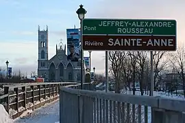
| Sainte-Anne-de-la-Pérade | 269.6 | 167.5 | Southern terminus of R-159 | ||||
| Portneuf | Deschambault-Grondines | 290.3 | 180.4 | Southern terminus of R-363 | |||
| Cap-Santé | 309.9 | 192.6 | Western terminus of R-358 | ||||
| 314.4 | 195.4 | A-40 exit 274 | |||||
| Neuville | 323.0 | 200.7 | Southern terminus of R-365 | ||||
| Québec | Saint-Augustin-de-Desmaures | 338.0 | 210.0 | Southern terminus of R-367 | |||
| Saint-Augustin-de-Desmaures–Québec boundary | 340.7 | 211.7 | A-40 exit 298; becomes Boulevard Wilfrid-Hamel | ||||
| Québec | 347.3 | 215.8 | Northern terminus of A-540 | ||||
| 350.0 | 217.5 | A-73/A-40 exit 141 | |||||
| 353.0 | 219.3 | A-740 exit 7 | |||||
| 355.5 | 220.9 | Eastern terminus of R-358 | |||||
| 357.3 | 222.0 | A-973/QC 175 exit 4 | |||||
| 357.8 | 222.3 | Boulevard Wilfrid-Hamel / Avenue Eugène-Lamontagne | R-138 follows Avenue Eugène-Lamontagne; becomes 18e Rue east of 1re Avenue | ||||
| 359.9– 360.1 | 223.6– 223.8 | R-138 follows Chemin de la Canardière for 1 block and continues on Boulevard Sainte-Anne; western terminus of R-360 | |||||
| 362.3 | 225.1 | ||||||
| 363.3– 363.8 | 225.7– 226.1 | A-440 exit 27 | |||||
| 367.7 | 228.5 | A-40 exit 325; eastern terminus of A-40; western terminus of R-368 | |||||
| La Côte-de-Beaupré | Sainte-Anne-de-Beaupré | 392.8 | 244.1 | West end of R-360 concurrency | |||
| 394.6 | 245.2 | Interchange; east end of R-360 concurrency | |||||
| Saint-Tite-des-Caps | 415.5 | 258.2 | Eastern terminus of R-360 | ||||
| Charlevoix | Baie-Saint-Paul | 448.6 | 278.7 | Interchange; western terminus of R-362 | |||
| 459.1 | 285.3 | Southern terminus of R-381 | |||||
| Charlevoix-Est | La Malbaie | 498.2 | 309.6 | Eastern terminus of R-362 | |||
| Saint-Siméon | 531.2 | 330.1 | Ferry connection to Rivière-du-Loup | ||||
| 531.8 | 330.4 | Eastern terminus of R-170 | |||||
| Saguenay River | 568.8 | 353.4 | Kilometrage does not include ferry | ||||
| La Haute-Côte-Nord | Tadoussac | 574.9 | 357.2 | Eastern terminus of R-172 | |||
| Les Escoumins | 607.3 | 377.4 | Ferry connection to Trois Pistoles | ||||
| Forestville | 665.7 | 413.6 | Ferry connection to Rimouski | ||||
| 667.4 | 414.7 | Eastern terminus of R-385 | |||||
| Manicouagan | Baie-Comeau | 765.0 | 475.3 | Ferry connection to Matane | |||
| 766.6 | 476.3 | Southern terminus of R-389; connects to Trans-Labrador Highway | |||||
| Franquelin | 804.6– 804.9 | 500.0– 500.1 | Saint-Nicolas Tunnel | ||||
| Godbout | 820.5 | 509.8 | Ferry connection to Matane | ||||
| Sept-Rivières | Sept-Îles | 942.4 | 585.6 | Ferry connections to Rimouski and Port-Menier | |||
| 950.0 | 590.3 | ||||||
| Minganie | Havre-Saint-Pierre | 1,157.6 | 719.3 | Ferry connections to Port-Menier and Natashquan | |||
| Natashquan | 1,307.2 | 812.3 | Ferry connections to Havre-Saint-Pierre and Kegaska | ||||
| Le Golfe-du-Saint-Laurent | Kegashka | 1,359.0 | 844.4 | Eastern terminus (main section); ferry connections to Natashquan and La Romaine | |||
| 150 km (95 mi) gap in Route 138 | |||||||
| Le Golfe-du-Saint-Laurent | Tête-à-la-Baleine | 0.0 | 0.0 | Western terminus (Tête-à-la-Baleine section) | |||
| 17.1 | 10.6 | Eastern terminus (Tête-à-la-Baleine section); ferry connections to Harrington Harbour and La Tabatière | |||||
| 140 km (85 mi) gap in Route 138 | |||||||
| Le Golfe-du-Saint-Laurent | Vieux Fort | 0.0 | 0.0 | Western terminus (Vieux Fort–Blanc-Sablon section) | |||
| Blanc-Sablon | 67.9 | 42.2 | Ferry connections to Saint-Augustin, Corner Brook, St. Barbe, and Route 430 | ||||
| 71.4 | 44.4 | Continues into Newfoundland and Labrador; eastern terminus of R-138 | |||||
1.000 mi = 1.609 km; 1.000 km = 0.621 mi
| |||||||
See also
- Quebec Route 2 (historical) and Chemin du Roy
- List of Quebec provincial highways
References
- ↑ Ministère des transports, "Distances routières", page 66-69, Les Publications du Québec, 2005
- ↑ The Ages of Exploration. "Jacques Cartier". The Mariners' Museum and ParK. Retrieved 2024-01-13.
Jacques Cartier is credited with discovering and claiming the land now known as Canada for France.
- ↑ Pierre Frenette (2009). "North Shore, a land of convergence" (PDF) (in French). Les Éditions Histoire Québec. p. 8. Retrieved 14 January 2024.
Logger-farmers swapped axes, harrows, and horses for saws, truck steering wheels, and bulldozer levers
- ↑ "Une nouvelle route pour Kegaska".
- ↑ "Le pont de Natashquan inauguré".
- ↑ Trans-Labrador Hwy - Labrador 2003 - Page 5
- ↑ "Québec invests an extra $122 million for the extension of route 138 on the Basse-Côte-Nord". Gouvernement du Québec. May 30, 2011. Retrieved 2013-11-07.
- ↑ Lévesque, Fanny (5 July 2013). "Extension of 138: Quebec terminates agreement with Pakatan Corporation". LeNord Côtier. Retrieved 26 Jun 2018.
- ↑ "Route 138 - Extension of Route 138 on the Lower North Shore". Gouvernement du Québec. Retrieved 25 June 2018.
- ↑ Google (March 24, 2023). "Route 138 in Quebec" (Map). Google Maps. Google. Retrieved March 24, 2023.
External links
- Provincial Route Map (Courtesy of the Quebec Ministry of Transportation) (in French)
- Overview Google map for QC 138 from Montreal border to Natashquan
- Overview Google map for QC 138 from Montreal to New York border
- Overview Google map for QC 138 from dead end to Newfoundland and Labrador border