Arnsberg
Regierungsbezirk Arnsberg | |
|---|---|
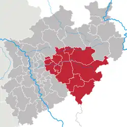
 Map of North Rhine-Westphalia highlighting Arnsberg | |
| Country | Germany |
| State | North Rhine-Westphalia |
| Region seat | Arnsberg |
| Area | |
| • Total | 8,002.34 km2 (3,089.72 sq mi) |
| Population (31 December 2021)[1] | |
| • Total | 3,565,239 |
| • Density | 450/km2 (1,200/sq mi) |
| GDP | |
| • Total | €131.845 billion (2021) |
| Vehicle registration | AR |
| Website | www |
Arnsberg (German pronunciation: [ˈaʁnsbɛʁk]) is one of the five Regierungsbezirke of North Rhine-Westphalia, Germany, located in the west-central part of the country. It covers the Sauerland hills as well as the east part of the Ruhr area.
The region was founded in 1815 as a subdivision of the Prussian Province of Westphalia.
Kreise
(counties)
Economy
The Gross domestic product (GDP) of the region was 124.8 billion € in 2018, accounting for 3.7% of German economic output. GDP per capita adjusted for purchasing power was 32,000 € or 106% of the EU27 average in the same year. The GDP per employee was 95% of the EU average.[3]
References
- ↑ "Bevölkerung der Gemeinden Nordrhein-Westfalens am 31. Dezember 2021" (in German). Landesbetrieb Information und Technik NRW. Retrieved 20 June 2022.
- ↑ "EU regions by GDP, Eurostat". Retrieved 18 September 2023.
- ↑ "Regional GDP per capita ranged from 30% to 263% of the EU average in 2018". Eurostat.
External links
![]() Media related to Regierungsbezirk Arnsberg at Wikimedia Commons
Media related to Regierungsbezirk Arnsberg at Wikimedia Commons
- Official website
 (in German)
51°15′N 8°20′E / 51.25°N 8.33°E
This article is issued from Wikipedia. The text is licensed under Creative Commons - Attribution - Sharealike. Additional terms may apply for the media files.