 | |
|---|---|
| Senai–Desaru Expressway | |
SDE in red | |
| Route information | |
| Maintained by Senai-Desaru Expressway Berhad (SDEB) | |
| Length | 77 km (48 mi) |
| Existed | 2005–present |
| History | Completed on 10 June 2011 |
| Major junctions | |
| West end | Senai |
| East end | Desaru |
| Location | |
| Country | Malaysia |
| Primary destinations | Senai, Ulu Tiram, Pasir Gudang, Bandar Penawar, Sungai Rengit, Pengerang, Desaru |
| Highway system | |
Senai–Desaru Expressway, SDE ![]() Senai–Desaru Expressway (Malay: Lebuhraya Senai–Desaru), is an expressway in Johor, Malaysia. It connects Senai in central Johor to Desaru in eastern Johor. Measuring a total length of 77 km (48 mi), it is the third east–west-oriented expressway in the Iskandar Malaysia area after the Pasir Gudang Highway and the Pontian–Johor Bahru Link of the Second Link Expressway.[1] With a new crossing over the Johor River, when opened on 10 June 2011, the expressway shortened travel time from Senai to Desaru from 2.5 hours to one hour.[2]
Senai–Desaru Expressway (Malay: Lebuhraya Senai–Desaru), is an expressway in Johor, Malaysia. It connects Senai in central Johor to Desaru in eastern Johor. Measuring a total length of 77 km (48 mi), it is the third east–west-oriented expressway in the Iskandar Malaysia area after the Pasir Gudang Highway and the Pontian–Johor Bahru Link of the Second Link Expressway.[1] With a new crossing over the Johor River, when opened on 10 June 2011, the expressway shortened travel time from Senai to Desaru from 2.5 hours to one hour.[2]
The Kilometre Zero of the expressway is located at Senai Main Interchange at Senai.
History
The Johor Bahru–Kota Tinggi Highway (Federal Route 3) and Pengerang Highway (Federal Route 92) used to be the only gateway to Desaru, with a typical journey of 2.5 hours. Construction of the expressway began in 2005. The construction was led by Senai–Desaru Expressway Berhad with a main contractor, Ranhill Engineers & Constructors Sdn Bhd. Phase 1 of the expressway linking Senai to Pasir Gudang was opened to traffic on 10 September 2009, and the remaining stretch from Pasir Gudang to Desaru, including the bridge, opened on 10 June 2011.
On 12 December 2017, former Works Minister Fadillah Yusof had announced that the government approved to allocate RM390 million to upgrade and expand the 26 km stretch from Cahaya Baru to the Bandar Penawar intersection into dual carriageway.[3] However, a session was held on 17 July 2018 between the current Finance Ministry, the Works Ministry and the Economic Planning Unit to identify the list of Works Ministry projects that had not been issued acceptance letters, as well as the project savings. Following this session, Johor's State Public Works, Infrastructure and Transportation Committee chairman Mazlan Bujang said the federal government had postponed this project indefinitely on 9 December 2018.[3]
Features
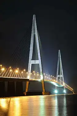
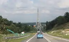
The tolled expressway is a combination of a four-lane dual carriageway (Senai–Cahaya Baru section) and a two-lane single carriageway (Cahaya Baru–Penawar section), which improves road connection between western and eastern Johor. It features a closed toll system like the North–South Expressway. It is also an alternative route to Desaru Beach, instead of Federal Routes 3 and 92 from Johor Bahru and Singapore. The highway has become the main access road to Desaru from North–South Expressway Southern Route E2 and a major road link to Senai International Airport from Kota Tinggi and eastern parts of Johor. Construction of the road included the 1.7 kilometre Sungai Johor-SDE Bridge, the longest single plane cable stayed bridge in Malaysia across Johor River, which became the longest river bridge in Malaysia after Batang Sadong Bridge in Sarawak.
The section between Cahaya Baru and Penawar is built as a two-lane expressway (except the Sungai Johor-SDE bridge) while retaining the full access control, making the section as the first true two-lane expressway with full access control in Malaysia.[4]
There is a water catchment area located along Sungai Layang sections near the Sultan Iskandar Reservoir. Senai–Desaru Expressway traverses through the environmentally sensitive water catchment area of Sultan Iskandar Reservoir. Senai–Desaru Expressway is the only expressway in Malaysia which features the Pollutant Removal System (PRS). The expressway took one step higher by introducing the PRS to monitor and control any potential impact to the water quality in Sultan Iskandar Reservoir in the event of a spillage of dangerous and hazardous chemicals from any vehicle travelling on the expressway.[5]
Toll systems
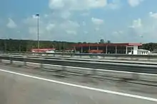
The Senai–Desaru Expressway uses the closed toll system. Beginning 9 November 2016, all electronic toll transactions have been conducting using Touch 'n Go and SmartTAGs.
Toll rates
| Class | Type of vehicles | Rate (in Malaysian Ringgit (RM)) up to |
|---|---|---|
| 0 | Motorcycles (Vehicles with two axles and two wheels) | Free |
| 1 | Private Cars (Vehicles with two axles and three or four wheels (excluding taxis and buses)) | 9.20 |
| 2 | Vans and other small goods vehicles (Vehicles with two axles and six wheels (excluding buses)) | 13.80 |
| 3 | Large Trucks (Vehicles with three or more axles (excluding buses)) | 18.40 |
| 4 | Taxis | 4.60 |
| 5 | Buses | 5.70 |
List of interchanges
Main Link
| Km | Exit | Interchange | To | Remarks |
|---|---|---|---|---|
0 | 2201 | Utama Senai Interchange Second Link Expressway | Southwest Northeast Senai Industrial Area | Expressway trumpet interchange |
PLUS Expressway border limit | ||||
SDEB border limit | ||||
| Sungai Skudai bridge | ||||
| 2202 | Bandar Senai Interchange | Southwest | Cloverleaf interchange | |
SNI | Customer Service Centre | |||
| Senai toll plaza SNI RM (Cash) Touch 'n Go SmartTAG MyRFID Transit Card Closed toll systems Collect a transit card and pay a distance toll | ||||
5 | ||||
| Kulai-Johor Bahru district border Johor Bahru sub district border | ||||
5 | ||||
| Sungai Tebrau Bridge | ||||
22 | ||||
| 2204 | Ulu Tiram Interchange ULT TnG TAG Customer Service Centre | North South | Trumpet interchange with toll plaza | |
29 | ||||
| 29.5 | West bound | |||
30 | ||||
| 30.5 | East bound | |||
31 | ||||
| Water Catchment Area | ||||
| Sungai Layang Viaduct | Start/End of viaduct Water Catchment Area | |||
| Sungai Layang Viaduct Sungai Layang Bridge | Water Catchment Area | |||
| Sungai Layang Viaduct | Start/End of viaduct Water Catchment Area | |||
| Water Catchment Area | ||||
| Johor Bahru-Pasir Gudang sub district border | ||||
42 | ||||
| 2205 | Cahaya Baru Interchange | South | Closed tolled expressway trumpet interchange | |
| Start/End of dual carriageway expressway Maximum speed 110 km/h Start/End of single carriageway expressway Maximum speed 90 km/h | ||||
47 | ||||
| Selat Mendana Bridge | ||||
48 | Pulau Juling | |||
| Start/End of single carriageway expressway | ||||
| Sungai Johor-SDE Bridge 1.7 km Johor River | Start/End of bridge Start/End of dual carriageway expressway | |||
| Sungai Johor-SDE Bridge 1.7 km Johor River Johor Bahru-Kota Tinggi district border Pasir Gudang-Bandar Pengerang sub district border | ||||
| Sungai Johor-SDE Bridge 1.7 km Johor River | Start/End of bridge Start/End of dual carriageway expressway | |||
| Start/End of single carriageway expressway | ||||
50 | Tanjung Penyabong | |||
53 | ||||
| Sungai Layau Bridge | ||||
59 | ||||
| Sungai Semenchu Bridge | ||||
61 | ||||
| Sungai Papan Bridge | ||||
68 | ||||
| Start/End of single carriageway expressway | ||||
| Penawar toll plaza PWR Transit Card Touch 'n Go SmartTAG MyRFID RM (Cash) Closed toll systems Collect a transit card and pay a distance toll | ||||
PWR | Customer Service Centre | |||
69 | Start/End of dual carriageway expressway | |||
Start/End of expressway SDEB border limit | ||||
| JKR border limit | ||||
| 2212 | Penawar Interchange | North South Pularek TLDM naval academy Sebana Resort | Intersections | |
Pasir Gudang Link
| Km | Exit | Interchange | To | Remarks |
|---|---|---|---|---|
| 2205 | Cahaya Baru Interchange | West East Sungai Johor-SDE Bridge | Closed tolled expressway trumpet interchange | |
| Cahaya Baru toll plaza CBU Transit Card Touch 'n Go SmartTAG MyRFID RM (Cash) Closed toll systems Collect a transit card and pay a distance toll | ||||
CBU | Customer Service Centre | |||
| 2205A | Masai Interchange | Entry/Exit interchange | ||
| 2207 | Kota Masai Interchange | Jalan Kota Masai-Kota Masai | From west/To east only | |
-- | ||||
Start/End of expressway SDEB border limit | ||||
| JKR border limit | ||||
-- | 2210 | Pasir Gudang Interchange | West East | Interchange |
References
- ↑ "SDE, Senai-Desaru Expressway (E22) | Malaysia Airport KLIA2 info". www.klia2.info. Retrieved 16 February 2019.
- ↑ "75km Senai-Desaru Expressway opens today". News.asiaone.com. New Straits Times. 10 June 2011. Archived from the original on 14 June 2011. Retrieved 11 November 2013.
- 1 2 "Green light for upgrading works on Senai-Desaru Expressway | The Star".
- ↑ "Reviu eksklusif Lebuhraya Senai-Desaru E22" (in Malay). Blog Jalan Raya Malaysia. 23 August 2012. Retrieved 12 February 2014.
- ↑ "senai desaru expressway berhad - About Us". E22.com.my. Retrieved 21 December 2018.
External links
- Senai-Desaru Expressway - Pleasureable, Valued & Safe Journey
- Longest cable-stayed bridge planned (The Star, 18 December 2006)