Throckmorton, Texas | |
|---|---|
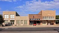
 Downtown Throckmorton in 2015 | |
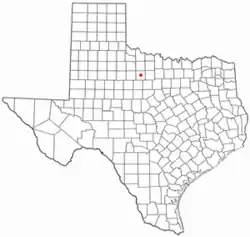
 Location of Throckmorton, Texas | |
 | |
| Coordinates: 33°10′53″N 99°10′41″W / 33.18139°N 99.17806°W | |
| Country | United States |
| State | Texas |
| County | Throckmorton |
| Area | |
| • Total | 1.66 sq mi (4.29 km2) |
| • Land | 1.66 sq mi (4.29 km2) |
| • Water | 0.00 sq mi (0.00 km2) |
| Elevation | 1,319 ft (402 m) |
| Population (2010) | |
| • Total | 828 |
| • Estimate (2019)[2] | 761 |
| • Density | 459.26/sq mi (177.29/km2) |
| Time zone | UTC-6 (Central (CST)) |
| • Summer (DST) | UTC-5 (CDT) |
| ZIP code | 76483 |
| Area code | 940 |
| FIPS code | 48-72896[3] |
| GNIS feature ID | 1369910[4] |
| Website | throckmortontx.org |
Throckmorton is a town in Throckmorton County, Texas, United States. Its population was 828 at the 2010 census. It is the county seat of Throckmorton County.[5]
Geography
Throckmorton is located at 33°10′53″N 99°10′41″W / 33.18139°N 99.17806°W (33.181399, –99.178173).[6]
According to the United States Census Bureau, the town has a total area of 1.7 sq mi (4.4 km2), all of it land.
Climate
The climate in this area is characterized by hot, humid summers and generally mild to cool winters. According to the Köppen climate classification, Throckmorton has a humid subtropical climate, Cfa on climate maps.[7]
Demographics
| Census | Pop. | Note | %± |
|---|---|---|---|
| 1880 | 37 | — | |
| 1890 | 240 | 548.6% | |
| 1920 | 686 | — | |
| 1930 | 1,135 | 65.5% | |
| 1940 | 1,133 | −0.2% | |
| 1950 | 1,320 | 16.5% | |
| 1960 | 1,299 | −1.6% | |
| 1970 | 1,105 | −14.9% | |
| 1980 | 1,174 | 6.2% | |
| 1990 | 1,036 | −11.8% | |
| 2000 | 905 | −12.6% | |
| 2010 | 828 | −8.5% | |
| 2019 (est.) | 761 | [2] | −8.1% |
| U.S. Decennial Census[8] | |||
2020 census
| Race | Number | Percentage |
|---|---|---|
| White (NH) | 616 | 84.73% |
| Black or African American (NH) | 1 | 0.14% |
| Native American or Alaska Native (NH) | 1 | 0.14% |
| Asian (NH) | 1 | 0.14% |
| Mixed/Multi-Racial (NH) | 24 | 3.3% |
| Hispanic or Latino | 84 | 11.55% |
| Total | 727 |
As of the 2020 United States census, there were 727 people, 337 households, and 169 families residing in the town.
2010 census
As of the census of 2010, 828 people, a decrease of 8.51% since 2000, lived in Throckmorton. The city had 477 housing units, with 116 of them vacant. The racial makeup of the town was 93.50% White, 0.12% African American, 0.97% Native American, 0.48% Asian, 4.11% from other races, and 0.85% from two or more races. Hispanics or Latinos of any race were 10.27% of the population.
2000 census
As of the census[3] of 2000, 905 people, 386 households, and 265 families resided in the town. The population density was 539.4 people/sq mi (208.0/km2). The 477 housing units averaged 284.3/sq mi (109.6/km2). The racial makeup of the town was 90.50% White, 0.11% African American, 0.11% Native American, 7.29% from other races, and 1.99% from two or more races. Hispanics or Latinos of any race were 12.04% of the population.
Of the 386 households, 29.8% had children under the age of 18 living with them, 55.2% were married couples living together, 10.6% had a female householder with no husband present, and 31.1% were not families. About 29.0% of all households were made up of individuals, and 16.8% had someone living alone who was 65 years of age or older. The average household size was 2.34 and the average family size was 2.87.
In the town, the population was distributed as 25.4% under the age of 18, 5.3% from 18 to 24, 23.5% from 25 to 44 26.4% from 45 to 64, and 19.3% who were 65 years of age or older. The median age was 42 years. For every 100 females, there were 100.2 males. For every 100 females age 18 and over, there were 91.2 males.
The median income for a household in the town was $29,453, and for a family was $36,250. Males had a median income of $22,778 versus $20,625 for females. The per capita income for the town was $16,400. About 11.7% of families and 16.0% of the population were below the poverty line, including 26.7% of those under age 18 and 7.7% of those age 65 or over.
Education
The Town of Throckmorton is served by the Throckmorton Collegiate Independent School District and home to the Throckmorton High School Greyhounds.
Notable people
- Deborah Scaling Kiley, a sailor, author, and shipwreck survivor, was born in Throckmorton.[12] She wrote Albatross: The True Story of a Woman's Survival at Sea (1994), about her survival while others were eaten alive by sharks. She wrote No Victims Only Survivors (2006)[13] about the psychology necessary to survive the ordeal. Her courage is commended and explored in the book Deep Survival: Who Lives, Who Dies, and Why by Laurence Gonzales.
- Bob Lilly, a Pro Football Hall of Fame defensive tackle for the Dallas Cowboys (1961–1974), was born in Olney in 1939 and raised in Throckmorton; he attended its schools until 1956. Because of the 1950s drought, his family moved to Pendleton, Oregon, where Lilly went to Pendleton High School for his senior year. He returned to Texas in 1957 and played college football at TCU in Fort Worth[14]
References
- ↑ "2019 U.S. Gazetteer Files". United States Census Bureau. Retrieved August 7, 2020.
- 1 2 "Population and Housing Unit Estimates". United States Census Bureau. May 24, 2020. Retrieved May 27, 2020.
- 1 2 "U.S. Census website". United States Census Bureau. Retrieved January 31, 2008.
- ↑ "US Board on Geographic Names". United States Geological Survey. October 25, 2007. Retrieved January 31, 2008.
- ↑ "Find a County". National Association of Counties. Retrieved June 7, 2011.
- ↑ "US Gazetteer files: 2010, 2000, and 1990". United States Census Bureau. February 12, 2011. Retrieved April 23, 2011.
- ↑ Climate Summary for Throckmorton, Texas
- ↑ "Census of Population and Housing". Census.gov. Retrieved June 4, 2015.
- ↑ "Explore Census Data". data.census.gov. Retrieved May 19, 2022.
- ↑ https://www.census.gov/
- ↑ "About the Hispanic Population and its Origin". www.census.gov. Retrieved May 18, 2022.
- ↑ Albatross: The True Story of a Woman's Survival at Sea. Houghton Mifflin Company. 1994. p. 18. ISBN 0-395-65573-0.
- ↑ No Victims Only Survivors: Ten Lessons for Survival. NVOS Publishing. 2006. ISBN 978-0-9778207-0-2.
- ↑ "Biography". BobLilly.com. Archived from the original on March 8, 2016. Retrieved March 13, 2016.
External links
![]() Media related to Throckmorton, Texas at Wikimedia Commons
Media related to Throckmorton, Texas at Wikimedia Commons
