| Massachusetts's 10th congressional district | |
|---|---|
| Obsolete district | |
| Created | 1795 |
| Eliminated | 2010 |
| Years active | 1795–2013 |
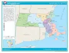
Massachusetts's 10th congressional district is an obsolete district that was active during 1795–2013. It was first located in the District of Maine during 1795–1803, then located in several different areas of Massachusetts. It was most recently eliminated in 2013 as district lines were redrawn to accommodate the loss of the seat due to reapportionment as a result of the 2010 census.[1]
At the time the district was eliminated, it included parts of the South Shore and all of the Cape and Islands. Effective with the 2012 House elections, most of the former district was placed in the 9th district, with some northern portions placed in the 8th district.[2]
Notable persons elected to the U.S. House of Representatives from the 10th congressional district include James Michael Curley, four-time Mayor of Boston, and John F. Fitzgerald, maternal grandfather of John F. Kennedy.
Cities and towns in the district prior to 2013

1840s
1843: "The Counties of Barnstable, Dukes, and Nantucket, together with the towns of Rochester and Wareham, in the County of Plymouth, and of Dartmouth, Fairhaven, and New Bedford, in the County of Bristol."[3]
1860s
1869: "Berkshire and Hampden counties."[4]
1870s–1880s
1890s–1950s
1893: Boston, Wards 13, 14, 15, 19 (Precincts 1, 5, 7, 8, 9), 20, 22, 24; Milton, Quincy.[5]
1916: Boston, Wards 1, 2, 3, 4, 5, 6, 7, 8, 9, 11 (Precincts 1, 2).[6]
1921: Boston, Wards 1, 2, 3, 4, 5, 6.[7]
1934: Boston, Wards 4, 5, 9, 10, 11, 12, 19, 20, 21.[8]
1941–1953: Boston, Wards 4, 5, 10, 12, 19, 20, 21; Brookline, Newton.[9][10]
1960s–1970s
1963: "Bristol County: Cities of Attleboro, Fall River, and Taunton. Towns of Berkley, Dighton, Easton, Freetown, Mansfield, North Attleboro, Norton, Raynham, Rehoboth, Seekonk, Somerset, and Swansea. Middlesex County: City of Newton. Norfolk County: Towns of Dover, Foxborough, Medfield, Needham, Norfolk, Plainville, Walpole, Wellesley, Westwood, and Wrentham."[11]
1977: "Bristol County: Cities of Attleboro, Fall River, and Taunton. Towns of Berkley, Dighton, Easton, Freetown, Mansfield, North Attleborough, Norton, Raynham, Rehoboth, Seekonk, Somerset, Swansea, and Westport. Middlesex County: Towns of Natick and Sherborn. Norfolk County: Towns of Foxborough, Medfield, Millis, Norfolk, Plainville, Sharon, Wellesley, and Wrentham. Plymouth County: Towns of Bridgewater, East Bridgewater, Halifax, Hanson, Lakeville, Middleborough, and West Bridgewater."[12]
1990s
1997: "Counties: Barnstable, Dukes, Nantucket, Norfolk (part), and Plymouth (part)."[13]
2003–2013
- All of Barnstable County, Dukes County, Nantucket County,
- The following municipalities in Plymouth County: Abington, Carver, Duxbury, Hanover, Hanson Pct. 2, Hingham, Hull, Kingston, Marshfield, Norwell, Pembroke, Plymouth, Plympton, Rockland, Scituate, and
- The following municipalities in Norfolk County: Cohasset, Quincy, Weymouth
List of members representing the district
References
- General
- 1 2 "Table 1. APPORTIONMENT POPULATION AND NUMBER OF REPRESENTATIVES, BY STATE: 2010 CENSUS" (PDF). December 21, 2010. Archived from the original (PDF) on January 24, 2011. Retrieved December 21, 2010.
- ↑ http://www.sec.state.ma.us/spr/sprcat/catpdf2010/cong2010/CongressionalDistrict_2011State.pdf Access date: March 20, 2012.
- ↑ "State Apportionment; districts of the Commonwealth for the choice of one representative to Congress in each district". Massachusetts Register ... for 1843. Boston: Loring.
- 1 2 Ben. Perley Poore (1869). "Massachusetts". Congressional Directory for the First Session of the Forty-First Congress (2nd ed.). Washington DC: Government Printing Office.
- ↑ Francis M. Cox (1893). "Massachusetts". Official Congressional Directory: Fifty-Third Congress (2nd ed.). Washington DC: Government Printing Office.
- ↑ "Massachusetts". Official Congressional Directory: 64th Congress (2nd ed.). Washington DC: Government Printing Office. 1916.
- ↑ Commonwealth of Massachusetts (1921), "Population of Congressional Districts", Population of Massachusetts as determined by the fourteenth census of the United States 1920, Boston: Wright & Potter
- ↑ "Massachusetts". Official Congressional Directory: 73rd Congress (2nd ed.). Washington DC: Government Printing Office. 1934.
- ↑ Commonwealth of Massachusetts (1941), "Population of Congressional Districts", Population of Massachusetts as determined by the sixteenth census of the United States, 1940, Boston: Wright & Potter, OCLC 10056477,
House No. 2849
- ↑ "Massachusetts". Official Congressional Directory: 83rd Congress. Washington DC: Government Printing Office. 1953.
- ↑ "Massachusetts". Official Congressional Directory: 88th Congress. Washington DC: Government Printing Office. 1963.
- ↑ "Massachusetts", 1977 Official Congressional Directory: 95th Congress, Washington DC: U.S. Government Printing Office, 1977
- ↑ Congressional Directory for the 105th Congress (1997–1998), Washington DC: U.S. Government Printing Office, 1997, retrieved November 26, 2013
- ↑ "Massachusetts". Congressional Directory for the Second Session of the Thirty-Seventh Congress. Washington DC: House of Representatives. 1861.
- ↑ Ben. Perley Poore (1878). "Massachusetts". Congressional Directory: 45th Congress (3rd ed.). Washington DC: Government Printing Office.
- ↑ Ben. Perley Poore (1882). "Massachusetts". Congressional Directory: 47th Congress (3rd ed.). Washington DC: Government Printing Office.
- ↑ L.A. Coolidge (1897). "Massachusetts". Official Congressional Directory: Fifty-Fifth Congress. Washington DC: Government Printing Office.
- ↑ A.J. Halford (1909). "Massachusetts". Congressional Directory: 60th Congress (2nd ed.). Washington DC: Government Printing Office.
- ↑ "Massachusetts". Official Congressional Directory: 75th Congress (2nd ed.). Washington DC: Government Printing Office. 1938.
- ↑ "Massachusetts". Official Congressional Directory: 90th Congress. Washington DC: Government Printing Office. 1968.
- ↑ "Massachusetts". 1991–1992 Official Congressional Directory: 102nd Congress. Washington DC: Government Printing Office. 1991.
- Specific
- Martis, Kenneth C. (1989). The Historical Atlas of Political Parties in the United States Congress. New York: Macmillan Publishing Company.
- Martis, Kenneth C. (1982). The Historical Atlas of United States Congressional Districts. New York: Macmillan Publishing Company.
- Congressional Biographical Directory of the United States 1774–present
External links
- "Our Campaigns – United States – Massachusetts – MA – District 10". www.ourcampaigns.com. Retrieved December 31, 2020.
Maps
- Map of Massachusetts's 10th Congressional District, via Massachusetts Secretary of the Commonwealth


.jpg.webp)







.jpg.webp)


.jpg.webp)

