Vitina | |
|---|---|
Village | |
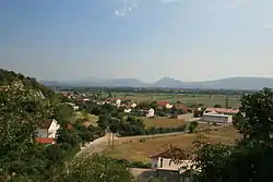 Panoramic view from mount Zelengora of Vitina | |
 Vitina | |
| Coordinates: 43°14′15″N 17°29′02″E / 43.2375°N 17.4839°E | |
| Country | |
| Entity | Federation of Bosnia and Herzegovina |
| Canton | |
| Municipality | |
| Area | |
| • Total | 7.37 sq mi (19.08 km2) |
| Population (2013) | |
| • Total | 1,951 |
| • Density | 260/sq mi (100/km2) |
| Time zone | UTC+1 (CET) |
| • Summer (DST) | UTC+2 (CEST) |
Vitina is a village in Bosnia and Herzegovina. According to the 1991 census, the village is located in the municipality of Ljubuški.[1]
Demographics
According to the 2013 census, its population was 1,951.[2]
| Ethnicity | Number | Percentage |
|---|---|---|
| Croats | 1,920 | 98.4% |
| Bosniaks | 13 | 0.7% |
| Serbs | 2 | 0.1% |
| other/undeclared | 16 | 0.8% |
| Total | 1,951 | 100% |
References
- ↑ Official results from the book: Ethnic composition of Bosnia-Herzegovina population, by municipalities and settlements, 1991. census, Zavod za statistiku Bosne i Hercegovine - Bilten no.234, Sarajevo 1991.
- ↑ "Naseljena Mjesta 1991/2013" (in Bosnian). Statistical Office of Bosnia and Herzegovina. Retrieved September 21, 2021.
Wikimedia Commons has media related to Vitina (Ljubuški).
This article is issued from Wikipedia. The text is licensed under Creative Commons - Attribution - Sharealike. Additional terms may apply for the media files.