| Aso | |
|---|---|
 | |
| Location | |
| Country | Italy |
| Physical characteristics | |
| Source | |
| • location | Monti Sibillini, near Foce |
| • elevation | 950 m (3,120 ft) |
| Mouth | Adriatic Sea |
• location | Pedaso |
• coordinates | 43°06′11″N 13°50′32″E / 43.1030°N 13.8422°E |
• elevation | 0 m (0 ft) |
| Length | 63 km (39 mi) |
| Basin size | 242 km2 (93 sq mi) |
| Discharge | |
| • average | 2.6 m3/s (92 cu ft/s) |
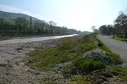
The Aso (Latin: Helvinus)[1] is a 63-kilometre (39 mi) river in the Marche region of Italy. For most of its course the river marks the boundary between the provinces of Ascoli Piceno and Fermo
The river's source is in the Monti Sibillini, near Foce in the Comune of Montemonaco, at an elevation of 950 metres (3,120 ft). The Aso flows through the settlements of Tofe, San Giorgio all’Isola, Illice, Piane, Comunanza, Montecchio, Madonna del Lago, Aso and Rubbianello before entering the Adriatic Sea at Pedaso, where it delivers a mean discharge of 2.6 cubic metres per second (92 cu ft/s).
See also
References
This article is issued from Wikipedia. The text is licensed under Creative Commons - Attribution - Sharealike. Additional terms may apply for the media files.