Burlington Historic District | |
 | |
   | |
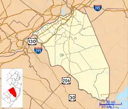
| Location | Roughly L-shaped, bounded by Delaware River and High, W. Broad, Albot, and Reed Sts., Burlington, New Jersey |
|---|---|
| Coordinates | 40°4′43″N 74°51′50″W / 40.07861°N 74.86389°W |
| Area | 31 acres (13 ha) |
| Architect | William Strickland; Richard Upjohn |
| Architectural style | Gothic, Gothic Revival |
| NRHP reference No. | 75001124[1] |
| NJRHP No. | 758[2] |
| Significant dates | |
| Added to NRHP | March 13, 1975 |
| Designated NJRHP | July 1, 1974 |
The Burlington Historic District in Burlington, New Jersey, United States, is a historic district bounded by the Delaware River and High, West Broad, Talbot, and Reed streets; it is listed on state and federal registers of historic places.[2][3] The oldest building in Burlington County and one of the oldest residences in New Jersey, the Revell House, is a contributing property. St. Mary's Episcopal Church, built in 1703 and the oldest church in New Jersey, is also within the district; the new St. Mary's, designed by Richard Upjohn and completed in 1854, has separate status as a National Historic Landmark. This district is adjacent to the city's High Street Historic District.[3]
See also
References
- ↑ "National Register Information System". National Register of Historic Places. National Park Service. July 9, 2010.
- 1 2 "New Jersey and National Registers of Historic Places". New Jersey Department of Environmental Protection - Historic Preservation Office. Retrieved 2016-01-19.
- 1 2 Historic District Map City of Burlington June 17, 2014
External links
- Tour Burlington Archived 2020-05-03 at the Wayback Machine
This article is issued from Wikipedia. The text is licensed under Creative Commons - Attribution - Sharealike. Additional terms may apply for the media files.