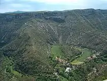
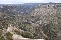
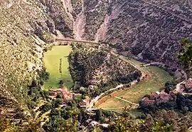
The Cirque de Navacelles is large erosional landform, an incised meander, located towards the southern edge of the Massif Central mountain range in France. It is located near Saint-Maurice-Navacelles and Blandas between the Hérault department and the Gard department.[1]
The cirque is isolated, with only a few small villages in the surrounding area. However, with the completion of the Millau Viaduct in 2004 and the A75 motorway between Clermont-Ferrand and Pézenas, tourism in the region has increased.
Fluvial processes in the cirque
The area is an example of a dissected plateau in which the Vis River eroded a deep channel through the base of the valley, creating an incised meander which eventually eroded through creating a cut-off at the neck of the loop.[2] This left an oxbow lake which later dried up, leaving deposits of silt and peat. This created what is the only patch of arable land for many miles around.
See also
Notes
- ↑ Official website: Geography of the cirque(in French)
- ↑ Official website: landscapes(in French)
External links
![]() Media related to Cirque de Navacelles at Wikimedia Commons
Media related to Cirque de Navacelles at Wikimedia Commons
- Interactive map(in French)
- Cévennes Visitor Center website(in French)
- Personal website: photographs of the Cirque