Clonlonan
Cluain Lonáin | |
|---|---|
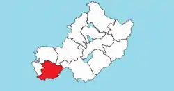
 Location of Clonlonan on a map of Westmeath | |
 Clonlonan Location in Ireland | |
| Coordinates: 53°23′48″N 7°47′35″W / 53.3967°N 7.7931°W | |
| Country | Ireland |
| Province | Leinster |
| County | Westmeath |
| Area | |
| • Total | 120.7 km2 (46.6 sq mi) |
| Time zone | UTC+0 (WET) |
| • Summer (DST) | UTC+1 (IST (WEST)) |
| Irish Grid Reference | N138385 |
Clonlonan (Irish: Cluain Lonáin)[1] is a barony in south–west County Westmeath, Ireland. It was formed by 1672.[2] It is bordered by County Offaly to the south and a small part of County Roscommon at Long Island on the River Shannon to the west. It also borders four other Westmeath baronies: Kilkenny West and Rathconrath (to the north), Moycashel (to the north–east) and Brawny (to the west). The largest centre of population in the barony is the town of Moate.
Geography
Clonlonan has an area of 29,820.6 acres (120.680 km2).[2]
The Boor River runs west from near Moate, and flows into the River Shannon at the boundary of Westmeath and County Offaly.[3]
Two significant roads pass through the barony. The M6, a motorway forming part of the N6 Dublin to Galway national primary road and the N62 connecting the M6 to the M8. In addition the R390, a regional road linking Athlone to Mullingar, the R444 linking the R357 at Shannonbridge, County Offaly with the N6 and the R446, part of the old N6 prior to the motorway, also feature.
A railway line carrying several of the national rail company Iarnród Éireann's intercity services also passes through the barony.
Civil parishes of the barony
This table[4] lists an historical geographical sub-division of the barony known as the civil parish (not to be confused with an Ecclesiastical parish).
| Name in English | Name in Irish |
|---|---|
| Ballyloughloe | Baile Locha Luatha |
| Kilcumreragh | Cill Chruimthir Fhiachrach |
| Kilmanaghan | Cill Mhancháin |
| Kilcleagh | – |
Towns, villages and townlands
_-_geograph.org.uk_-_1606693.jpg.webp)
- Moate, a town on the Cloghatanny River, also known as the Moate Stream, which is a tributary of the River Brosna.
- Ballynahown, a village on the N62 regional road 10 km (6.2 mi) south of Athlone and 5 km (3.1 mi) east of the River Shannon.
- Bealin
- Fardrum
- Mount Temple, a village about 6.5 km north–west of Moate.
- Moyvoughly, a hamlet north of Moate.
There are 130 townlands in the barony of Clonlonan.[2]
Places of interest
- Moate Castle, a former fortified house, built about 1550.[5]
References
- ↑ "Cluain Loná / Clonlonan". logainm.ie - The Placenames Database of Ireland. Retrieved 4 March 2021.
- 1 2 3 "Barony of Clonlonan, Co. Westmeath". townlands.ie. Retrieved 28 May 2015.
- ↑ County Westmeath – Rivers Library Ireland. Retrieved 2 July 2015
- ↑ Civil parishes of the barony of Clonlonan. The Placenames Database of Ireland. Retrieved 7 June 2015
- ↑ Moate Castle National Inventory of Architectural Heritage. Retrieved 2 July 2015
External links
- Map of the barony of Clonlonan at openstreetmap.org
- Barony of Clonlonan, County Westmeath at townlands.ie
