Harrison Township | |
|---|---|
 | |
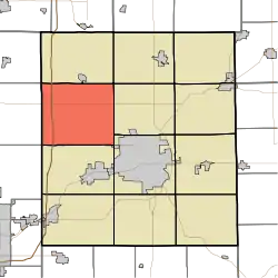
 Location of Harrison Township in Delaware County | |
| Coordinates: 40°15′36″N 85°30′35″W / 40.26000°N 85.50972°W | |
| Country | United States |
| State | Indiana |
| County | Delaware |
| Government | |
| • Type | Indiana township |
| Area | |
| • Total | 42.42 sq mi (109.9 km2) |
| • Land | 42.3 sq mi (110 km2) |
| • Water | 0.12 sq mi (0.3 km2) |
| Elevation | 896 ft (273 m) |
| Population (2020) | |
| • Total | 3,463[2] |
| • Density | 81.6/sq mi (31.5/km2) |
| FIPS code | 18-31756[3] |
| GNIS feature ID | 453384 |
Harrison Township is one of twelve townships in Delaware County, Indiana. According to the 2020 census, its population was 3,463 and it contained 1,462 housing units.[2]
History
The Job Garner-Jacob W. Miller House was listed on the National Register of Historic Places in 1986.[4]
Geography
According to the 2010 census, the township has a total area of 42.42 square miles (109.9 km2), of which 42.3 square miles (110 km2) (or 99.72%) is land and 0.12 square miles (0.31 km2) (or 0.28%) is water.[5] Emerald Lake is in this township.
Cities and towns
- Muncie, northwest edge
Unincorporated towns
Adjacent townships
- Washington Township (north)
- Union Township (northeast)
- Hamilton Township (east)
- Center Township (southeast)
- Mount Pleasant Township (south)
- Richland Township, Madison County (southwest)
- Monroe Township, Madison County (west)
- Van Buren Township, Madison County (northwest)
Major highways
Cemeteries
The township contains three cemeteries, Hinton and Nottingham.
Demographics
| Census | Pop. | Note | %± |
|---|---|---|---|
| 1890 | 2,041 | — | |
| 1900 | 2,106 | 3.2% | |
| 1910 | 1,782 | −15.4% | |
| 1920 | 1,539 | −13.6% | |
| 1930 | 1,513 | −1.7% | |
| 1940 | 1,519 | 0.4% | |
| 1950 | 1,600 | 5.3% | |
| 1960 | 1,927 | 20.4% | |
| 1970 | 2,983 | 54.8% | |
| 1980 | 3,585 | 20.2% | |
| 1990 | 3,336 | −6.9% | |
| 2000 | 3,425 | 2.7% | |
| 2010 | 3,327 | −2.9% | |
| 2020 | 3,463 | 4.1% | |
| U.S. Decennial Census[6] | |||
2020 census
As of the census[2] of 2020, there were 3,463 people, 1,312 households, and 646 families living in the township. The population density was 81.63 inhabitants per square mile (31.5/km2). There were 1,462 housing units at an average density of 34.46 per square mile (13.3/km2). The racial makeup of the township was 94.4% White, 9.8% African American, 6.4% Asian, 7.2% from other races, and 3.1% from two or more races. Hispanic or Latino of any race were 2.1% of the population.
There were 1,312 households, of which 28.6% had children under the age of 18 living with them, 49.2% were married couples living together, 9.1% had a female householder with no husband present, 3.8% had a male householder with no wife present, and 37.9% were non-families. 12.9% of all households were made up of individuals. The average household size was 2.64 and the average family size was 3.18.
21.5% of the population had never been married. 59.2% of residents were married and not separated, 9.3% were widowed, 10.0% were divorced, and 0.0% were separated.
The median age in the township was 38.9. 12.1% of residents were under the age of 5; 28.6% of residents were under the age of 18; 71.4% were age 18 or older; and 24.8% were age 65 or older. 6.4% of the population were veterans.
The most common language spoken at home was English with 98.4% speaking it at home, 0.5% spoke Spanish at home, 0.9% spoke another Indo-European language at home, and 0.2% spoke some other language. 1.4% of the population were foreign born.
The median household income in Harrison Township was $71,164, 26.7% greater than the median average for the state of Indiana. 13.2% of the population were in poverty, including 21.0% of residents under the age of 18. The poverty rate for the township was 0.3% higher than that of the state. 21.3% of the population were disabled and 6.4% had no healthcare coverage. 37.1% of the population had attained a high school or equivalent degree, 21.5% had attended college but received no degree, 9.9% had attained an Associate's degree or higher, 11.6% had attained a Bachelor's degree or higher, and 11.0% had a graduate or professional degree. 30.4% had no degree. 49.6% of Harrison Township residents were employed, working a mean of 38.4 hours per week. 150 housing units were vacant at a density of 3.5 per square mile (1.4/km2).
References
- "Harrison Township, Delaware County, Indiana". Geographic Names Information System. United States Geological Survey, United States Department of the Interior. Retrieved September 24, 2009.
- United States Census Bureau cartographic boundary files
- ↑ "US Board on Geographic Names". United States Geological Survey. October 25, 2007. Retrieved January 31, 2008.
- 1 2 3 "Harrison township, Delaware County, Indiana - Census Bureau Profile". The United States Census Bureau. p. 1. Archived from the original on May 2, 2022 – via Internet Archive.
- ↑ "U.S. Census website". United States Census Bureau. Retrieved January 31, 2008.
- ↑ "National Register Information System". National Register of Historic Places. National Park Service. July 9, 2010.
- ↑ "Population, Housing Units, Area, and Density: 2010 - State -- County Subdivision -- 2010 Census Summary File 1". United States Census. Archived from the original on February 12, 2020. Retrieved May 10, 2013.
- ↑ "Census of Population and Housing". Census.gov. Retrieved June 4, 2016.