Hickory Ridge | |
|---|---|
Village | |
| Country | United States |
| State | Maryland |
| City | Columbia |
| Established | 1974[1] |
| Named for | Hickory Ridge Plantation |

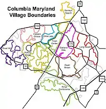
Hickory Ridge is one of the 10 villages in Columbia, Maryland, United States, located to the west of the Town Center with a 2014 population of 13,000 in 4,659 housing units.[2] The village overlays the former postal community of Elioak. It was first occupied in 1974.[3] Neighborhoods in the village are Hawthorn, Clary's Forest, and Clemens Crossing. The name Hickory Ridge is derived from the 1749 estate "Hickory Ridge" in nearby Highland,[4] which later became the family home of the nephew of hospital and university founder Johns Hopkins.[5][6]
Clary's Forest is named after John Clary's 100-acre original land grant patented on 10 June 1734.[7] Streets in Clary's Forest are based on the work of William Carlos Williams. Hawthorn is the name of an Amy Lowell poem. The street names come from her work. Clemens Crossing is named after American author Mark Twain, otherwise known as Samuel Clemens, and the street names come from Clemens' work.[3][8]

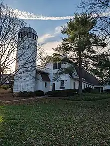
The land surrounding Sierra Villas Condominiums and Barnside Condominiums in Clary's Forest originally belonged to the Kahler family farm. The farm's silo remains in the condominium property.[3] The Kahler farm was one of three large tracts originally purchased by Robert Moxley that started the Columbia project in 1963.[9] Hickory Plaza was built on the site of Midway Farm, the last piece of a 400-acre (160 ha) farm owned by the Bassler family before the creation of the Rouse development.[10]
Services
The Village Center, opened in 1992, has a Giant Food grocery store, bank, restaurants, a gas station, and other establishments.[11] It is the first village center in Columbia built without a collocated community center, which resides in the Hawthorn neighborhood.[12] Howard County General Hospital is located in Hickory Ridge, at the intersection of Little Patuxent Parkway and Cedar Lane.[13]
The Howard County public schools Clemens Crossing Elementary School and Atholton High School are located in Hickory Ridge.[14] Howard Community College is also located in Hickory Ridge.[15]
Notable residents
- Linda Tripp, lived in Hickory Ridge during the Monica Lewinsky scandal[16]
References
- ↑ "About Us". hickoryridgevillage.org.
- ↑ "Map" Archived 2009-08-05 at the Wayback Machine, columbiavillages.org, accessed May 29, 2009
- 1 2 3 "History", hickoryridgecommunityassociation.org, accessed May 29, 2009
- ↑ Missy Burke; Robin Emrich; Barbara Kellner. Oh, You must live in Columbia. p. 41.
- ↑ Orton, Kathy (September 19, 2019). "A 'splendid' historical house, with a horse farm". The Washington Post. Retrieved July 6, 2022.
- ↑ "Historic Hickory Ridge" (PDF). highlandmd.org. Retrieved July 6, 2022.
- ↑ Collection Research: Land Owners & Patents, 1670–1812 ACCESSION NO. A.3.a. iii Property Owners, Land Names, & Acreage – covering Anne Arundel (Howard), Baltimore, Frederick, and Montgomery Counties.
- ↑ "How the Streets of Hickory Ridge were Named". columbiamaryland.com. Archived from the original on 2011-06-06.
- ↑ Edward Gunts (February 19, 2012). "Columbia Marks 50 Years since Rouse started buying land for town". The Baltimore Sun.
- ↑ Janene Holzberg (December 19, 2013). "Clarksville's Basslers say goodbye to family farm, Haysfield Airport". The Baltimore Sun.
- ↑ "Hickory Ridge Village Center". Columbia Village Centers. Archived from the original on 2007-02-04. Retrieved 2007-01-29.
- ↑ Joseph Rocco Mitchel; David L Stebenne (31 March 2007). New City Upon a Hill. Arcadia. p. 141. ISBN 9781614230991.
- ↑ Melissa McMacken (5 January 2015). "Howard County General Hospital – Award Winning Health Care in Howard County". hcgh.org.
- ↑ "Howard County Online School Directory". HCPSS.
- ↑ Wanda Garcia (19 February 2015). "HCC at a Glance". howardcc.edu. Archived from the original on 31 May 2009.
- ↑ Tkacik, Christina (April 9, 2020). "During Clinton-Lewinsky scandal, Linda Tripp was 'Columbia's most talked-about resident'". The Baltimore Sun. Retrieved April 9, 2020.
External links
- "The Village of Hickory Ridge – Quality Community Living In Columbia, MD". hickoryridgevillage.org. Hickory Ridge Community Association. Retrieved January 15, 2020.
- "Hickory Ridge Village Center, Columbia, MD". hickoryridge.shopkimco.com. Kimco Realty. 2020. Retrieved January 15, 2020.
