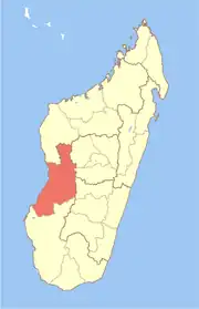
Isalo | |
|---|---|
 Isalo Location in Madagascar | |
| Coordinates: 19°44′S 45°26′E / 19.733°S 45.433°E | |
| Country | |
| Region | Menabe |
| District | Miandrivazo |
| Area | |
| • Land | 340.71 km2 (131.55 sq mi) |
| Elevation | 57 m (187 ft) |
| Population (209)[3] | |
| • Total | 12,930 |
| • Density | 38/km2 (100/sq mi) |
| Time zone | UTC3 (EAT) |
| Postal code | 617 |
Isalo is a rural municipality in Madagascar. It belongs to the district of Miandrivazo, which is a part of Menabe Region. The population of the commune was estimated to be approximately 12,930 in 2009.
Only Primary schooling is available. The majority 50% of the population of the commune are Farmers, while an additional 30% receives their livelihood from raising livestock. The most important crop is beans, while other important products are maize and rice. Services provide employment for 10% of the population. Additionally, fishing employs 10% of the population.[4]
Roads
This municipality is situated at 38 km south-west of Miandrivazo. Only unpaved secondary roads lead to the municipality. These are praticable but in a bad state of conversation and it takes 1.1/2h to reach the village.
Fokontany (villages)
8 villages (fokontany) are part of the municipality:
- Isalo - 2750 habitants
- Analambiby - 3524 habitants
- Soatana Morlot - 955 habitants
- Antsikida - 1250 habitants
- Bepaha - 1204 habitants
- Mahatsinjo - 1205 habitants
- Adabozato - 900 habitants
- Soafaniry Mahavelo (also called Beoro) - 1142 habitants
Rivers
The Tsiribihina River and the Mahajilo River that flows west of Bepaha in this municipality.
References
- ↑ La commune rurale d'Isalo
- ↑ Estimated based on DEM data from Shuttle Radar Topography Mission
- ↑ La commune rurale d'Isalo
- ↑ "ILO census data". Cornell University. 2002. Retrieved 9 March 2008.
19°44′S 45°26′E / 19.733°S 45.433°E
