| Lamb Range Queensland | |||||||||||||||
|---|---|---|---|---|---|---|---|---|---|---|---|---|---|---|---|
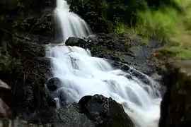
 Waterfall near Copperlode Falls Dam, 2008 | |||||||||||||||
 Lamb Range | |||||||||||||||
| Coordinates | 17°02′52″S 145°41′19″E / 17.0477°S 145.6886°E | ||||||||||||||
| Population | 0 (2016 census)[1] | ||||||||||||||
| • Density | 0.0000/km2 (0.000/sq mi) | ||||||||||||||
| Postcode(s) | 4870 | ||||||||||||||
| Area | 229.5 km2 (88.6 sq mi) | ||||||||||||||
| LGA(s) | Cairns Region | ||||||||||||||
| State electorate(s) | |||||||||||||||
| Federal division(s) | |||||||||||||||
| |||||||||||||||
Lamb Range is a locality in the Cairns Region, Queensland, Australia.[2] In the 2016 census, Lamb Range had a population of 0.[1]
Geography
The locality takes its name from the mountain range Lamb Range.[3]
The locality that lies to the west of most of the southern suburbs of Cairns. It is undeveloped mountainous land rising from the coastal plains (elevation of less than 50 metres above sea level) up through the Great Dividing Range (with elevations up to 1200 metres) towards the Atherton Tableland. The land use is entirely committed to national parks and reserves. Dinden National Park and Lake Morris Reserve are in the north of the locality with Little Mulgrave National Park in the south. A small area in the west is in the Danbulla National Park.[4]
There is only one road through the locality. The Gillies Range Road (also known as the Gillies Highway) passes through the south of the locality connecting Gordonvale in the Cairns Region with Atherton in the Tablelands Region. Lake Morris Road commences in Kanimbla and passes through Mooroobool and then travels through Lamb Range to Lake Morris but does not extend beyond the dam.[4]
Attractions

The Gillies Range Road is a 19 kilometres (12 mi) long road which ranges from an elevation of 20 metres to 820 metres. The road is winding with 263 corners and has a number of lookouts.[5]
References
- 1 2 Australian Bureau of Statistics (27 June 2017). "Lamb Range (SSC)". 2016 Census QuickStats. Retrieved 19 March 2018.
- ↑ "Lamb Range – locality in Cairns Region (entry 48724)". Queensland Place Names. Queensland Government. Retrieved 29 December 2017.
- ↑ "Lamb Range – range in the Tablelands Region (entry 18847)". Queensland Place Names. Queensland Government. Retrieved 18 March 2018.
- 1 2 "Queensland Globe". State of Queensland. Retrieved 18 March 2018.
- ↑ "Atherton Tablelands: From Cairns". Tropical Tablelands Tourism. Archived from the original on 18 March 2018. Retrieved 19 March 2018.
External links
![]() Media related to Lamb Range, Queensland at Wikimedia Commons
Media related to Lamb Range, Queensland at Wikimedia Commons