Le Puley | |
|---|---|
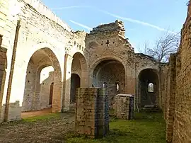
 The Priory | |
_en_Saone_et_Loire.svg.png.webp) Coat of arms | |
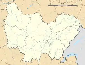
Location of Le Puley | |
 Le Puley  Le Puley | |
| Coordinates: 46°40′45″N 4°33′52″E / 46.6792°N 4.5644°E | |
| Country | France |
| Region | Bourgogne-Franche-Comté |
| Department | Saône-et-Loire |
| Arrondissement | Chalon-sur-Saône |
| Canton | Blanzy |
| Area 1 | 5.3 km2 (2.0 sq mi) |
| Population | 81 |
| • Density | 15/km2 (40/sq mi) |
| Time zone | UTC+01:00 (CET) |
| • Summer (DST) | UTC+02:00 (CEST) |
| INSEE/Postal code | 71363 /71460 |
| Elevation | 249–421 m (817–1,381 ft) (avg. 260 m or 850 ft) |
| 1 French Land Register data, which excludes lakes, ponds, glaciers > 1 km2 (0.386 sq mi or 247 acres) and river estuaries. | |
Le Puley (French pronunciation: [lə pylɛ]) is a commune in the Saône-et-Loire department in the region of Bourgogne-Franche-Comté in eastern France.
Geography
The main roads are connecting the village to Germagny and Genouilly to the south and Saint-Micaud to the north.
Main sights
The romanesque priory "Saint Christophe" (12th century), protected in 1973 by the French National Heritage as a Monument historique.[2] The belltower collapsed on the building in 1877, causing major damages.
See also
- Guillaume des Autels who used to own a château named "des Hôtels" in le Puley.
- Communes of the Saône-et-Loire department
References
- ↑ "Populations légales 2021". The National Institute of Statistics and Economic Studies. 28 December 2023.
- ↑ Base Mérimée: Monument historique registration number PA00113395, Ministère français de la Culture. (in French)
Wikimedia Commons has media related to Le Puley.
This article is issued from Wikipedia. The text is licensed under Creative Commons - Attribution - Sharealike. Additional terms may apply for the media files.