Merillat Airport | |||||||||||
|---|---|---|---|---|---|---|---|---|---|---|---|
 Airport office, hangar & control tower | |||||||||||
| Summary | |||||||||||
| Airport type | Public | ||||||||||
| Owner | James N. Merillat | ||||||||||
| Operator | Jeff Wright | ||||||||||
| Serves | Tecumseh, Michigan | ||||||||||
| Elevation AMSL | 820 ft / 250 m | ||||||||||
| Coordinates | 41°58′30″N 083°55′31″W / 41.97500°N 83.92528°W | ||||||||||
| Runways | |||||||||||
| |||||||||||
| Statistics (2019) | |||||||||||
| |||||||||||

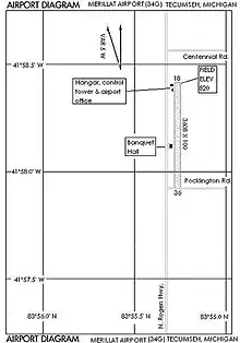
Merillat Airport (FAA LID: 34G) is a public use airport located three nautical miles (6 km) southeast of the central business district of Tecumseh, in Lenawee County, Michigan, United States. It is owned by James N. Merillatt and managed by Jeff Wright.[1] The airport opened in February 1976.[3] "The Landing" banquet hall is adjacent to the airport on N. Rogers Rd.[4]
Facilities and aircraft
Merillat Airport covers an area of 28 acres (11 ha) at an elevation of 820 feet (250 m) above mean sea level. It has one runway designated 18/36 with a turf surface measuring 3,608 by 100 feet (1,100 x 30 m).[1][2]
For the 12-month period ending December 31, 2021, the airport had 984 general aviation aircraft operations, an average of 82 per month. This is down from 2,280 annual operations in 2005. At that time there were 21 aircraft based at this airport: 20 single-engine airplanes and 1 ultralight.[1][3]
Accidents and incidents
- On December 5, 2001, a Miller Lancair 235 sustained substantial damage when it departed controlled flight and impacted terrain on takeoff from runway 18 at the Tecumseh Merillat Airport. The pilot said that the aircraft was pushed right of runway heading by winds during takeoff, and airspeed began to bleed off. The pilot lowered the nose to increase airspeed and brought the plane back over runway heading. The aircraft was subsequently hit with a gust of winds, and its wing impacted the runway, cause the pilot to lose control of the aircraft. The probable cause of the accident was found to be the pilot's failure to maintain aircraft control during the takeoff. Factors relating to the accident were the crosswind and the wind gusts.[5]
Gallery
 Runway facing north from Pocklington Rd.
 "The Landing" banquet hall
See also
References
- 1 2 3 4 FAA Airport Form 5010 for 34G PDF. Federal Aviation Administration. effective 29 July 2010.
- 1 2 FAA Airports GIS for 45G
- 1 2 3 Merillat Airport (34G) at AirNav.com
- ↑ The Landing-Rental Hall at Yelp.com
- ↑ "Miller Lancair 235 crash in Michigan (N417EM) | PlaneCrashMap.com". planecrashmap.com. Retrieved 2023-04-07.
External links
- Tecumseh, Merillat (34G) airport diagram from Michigan DOT
- Aerial image as of 28 April 1992 from USGS The National Map
- Resources for this airport:
- FAA airport information for 34G
- AirNav airport information for 34G
- FlightAware airport information and live flight tracker
- SkyVector aeronautical chart for 34G