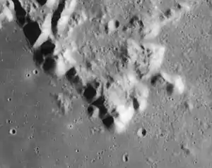
Promontorium Deville (left of center) and Promontorium Agassiz (below center), from Lunar Orbiter 4
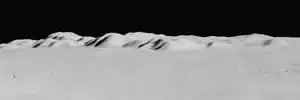
Oblique view showing Promontorium Agassiz (right), Promontorium Deville (left of center), and Mont Blanc (left, highest peak). From Apollo 15.
Promontorium Deville is a mountainous cape situated on the northeast margin of Mare Imbrium on the near side of the Moon. Its selenographic coordinates are 43.31° N, 1.14° E. It is located north of Promontorium Agassiz, south of Mont Blanc, northeast of Mons Piton, and northwest of Cassini crater.
Promontorium Deville is named after Charles Joseph Sainte-Claire Deville, a French meteorologist and geologist. The name of the feature was approved by the IAU in 1935.[1]
External links
- LAC-25, a map showing Promontorium Deville and surrounding area
References
- ↑ Promontorium Deville, Gazetteer of Planetary Nomenclature, International Astronomical Union (IAU) Working Group for Planetary System Nomenclature (WGPSN)

This article is issued from Wikipedia. The text is licensed under Creative Commons - Attribution - Sharealike. Additional terms may apply for the media files.