Rimbach-près-Masevaux | |
|---|---|
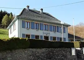
 The town hall in Rimbach-près-Masevaux | |
.svg.png.webp) Coat of arms | |
Location of Rimbach-près-Masevaux | |
 Rimbach-près-Masevaux  Rimbach-près-Masevaux | |
| Coordinates: 47°49′44″N 6°57′07″E / 47.8289°N 6.9519°E | |
| Country | France |
| Region | Grand Est |
| Department | Haut-Rhin |
| Arrondissement | Thann-Guebwiller |
| Canton | Masevaux-Niederbruck |
| Intercommunality | Vallée de la Doller et du Soultzbach |
| Government | |
| • Mayor (2020–2026) | André Schmuck[1] |
| Area 1 | 16.66 km2 (6.43 sq mi) |
| Population | 435 |
| • Density | 26/km2 (68/sq mi) |
| Time zone | UTC+01:00 (CET) |
| • Summer (DST) | UTC+02:00 (CEST) |
| INSEE/Postal code | 68275 /68290 |
| Elevation | 514–1,250 m (1,686–4,101 ft) (avg. 580 m or 1,900 ft) |
| 1 French Land Register data, which excludes lakes, ponds, glaciers > 1 km2 (0.386 sq mi or 247 acres) and river estuaries. | |
Rimbach-près-Masevaux (German: Rimbach bei Masmünster; variant form of name: Rimpach) is a commune in the Haut-Rhin department in Grand Est in north-eastern France.
Villages, hamlets and quarters in the commune: Basse Bers (Niederebersche, Unterbers, Untere Bers), Ermensbach (Armspach, Ermenspach, Ermerspach, Ermspach), Grossenberg (Grosberg), Haute Bers (Oberenbers), Horben (Horb), Johannesberg (Johannisberg, Sankt Johannisberg), Langmatt (Langmatte), Neuerbet (Neu Arbet, Neu Erbet), Riedelsbourg (Riedelsburg), Riesenwald, Ruchberg
Population
|
| ||||||||||||||||||||||||||||||||||||||||||||||||||||||||||||||||||||||||||||||||||||||||||||||||||||||||||||||||||
| Source: EHESS[3] and INSEE (1968-2017)[4] | |||||||||||||||||||||||||||||||||||||||||||||||||||||||||||||||||||||||||||||||||||||||||||||||||||||||||||||||||||
See also
Bibliography
- Patrimoine Dollar, the bulletin of the Société d'Histoire de la Vallée de Masevaux, publishes articles on Rimbach-près-Masevaux. Information on this journal can be obtained from the secrétaire-correspondent: M. Jean-Marie Ehret, 8 place de la Mairie, 68290 Oberbruck
- Two volumes of postcard views of this valley, compiled by Jean-Marie Ehret, Monique and Georges Redhaber, Bernard Sutter and Daniel Willmé, have been published by the Centre de Ressources des Vosges du Sud: La vallée de Masevaux à l'orée du siècle (1894–1914) (1995) and La vallée de Masevaux 1914-1918 (1997). Information can be obtained from: M. Armand Laurent, 1 rue du Buhl, 68290 Dolleren
- Historical and genealogical information from the Centre Départemental d'Histoire des Familles in Guebwiller: Rimbach-près-Masevaux
See also
References
- ↑ "Répertoire national des élus: les maires". data.gouv.fr, Plateforme ouverte des données publiques françaises (in French). 2 December 2020.
- ↑ "Populations légales 2021". The National Institute of Statistics and Economic Studies. 28 December 2023.
- ↑ Des villages de Cassini aux communes d'aujourd'hui: Commune data sheet Rimbach-près-Masevaux, EHESS (in French).
- ↑ Population en historique depuis 1968, INSEE
Wikimedia Commons has media related to Rimbach-près-Masevaux.
This article is issued from Wikipedia. The text is licensed under Creative Commons - Attribution - Sharealike. Additional terms may apply for the media files.