| Sandalee Glacier | |
|---|---|
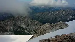 Portions of the Sandalee Glacier | |
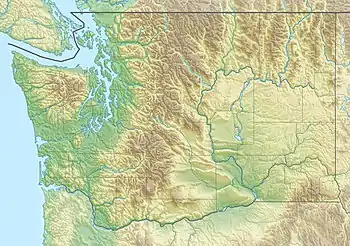 Sandalee Glacier Location in Washington | |
| Type | Cirque glacier |
| Location | Chelan County, Washington, U.S. |
| Coordinates | 48°24′31″N 120°47′18″W / 48.40861°N 120.78833°W[1] |
| Length | .45 mi (0.72 km) |
| Terminus | Barren rock |
| Status | Retreating |
Sandalee Glacier is in North Cascades National Park and Lake Chelan National Recreation Area in the U.S. state of Washington, on the north and east slopes of McGregor Mountain.[2] Sandalee Glacier originates in several cirques and extends from 7,800 to 6,800 ft (2,400 to 2,100 m) above sea level across a distance of almost 1.5 mi (2.4 km). In 1993, the Sandalee Glacier had an area of 2 km2.[3] The National Park Service is currently studying Sandalee Glacier as part of their glacier monitoring project.[3] Between 1993 (when monitoring began) and 2013 the glacier lost ~6 m of thickness.[4]
See also
References
- ↑ "Sandalee Glacier". Geographic Names Information System. United States Geological Survey, United States Department of the Interior. Retrieved May 18, 2013.
- ↑ McGregor Mountain, WA (Map). TopoQwest (United States Geological Survey Maps). Retrieved May 18, 2013.
- 1 2 "Glaciers Selected for Monitoring". Glacier Monitoring Program. National Park Service. Retrieved May 18, 2013.
- ↑ Riedel, Jon; Larrabee, Michael (2018). "North Cascades National Park Complex Glacier Mass Balance Monitoring Annual Report, Water Year 2013". National Park Service. Retrieved March 6, 2022.
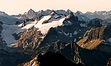
Sandalee Glacier on McGregor Mountain
This article is issued from Wikipedia. The text is licensed under Creative Commons - Attribution - Sharealike. Additional terms may apply for the media files.