Sucre Canton | |
|---|---|
 Flag  Seal | |
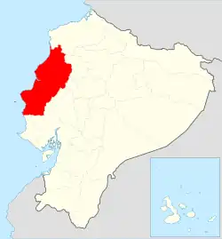
 Location of Manabí Province in Ecuador. | |
.svg.png.webp) Sucre Canton in Manabí Province | |
| Coordinates: 0°36′0″S 80°25′0″W / 0.60000°S 80.41667°W | |
| Country | |
| Province | Manabí Province |
| Area | |
| • Total | 693.5 km2 (267.8 sq mi) |
| Population (2022 census)[1] | |
| • Total | 62,841 |
| • Density | 91/km2 (230/sq mi) |
| Time zone | UTC-5 (ECT) |
Sucre Canton is a canton of Ecuador, located in the Manabí Province. Its capital is the city of Bahía de Caráquez. Its population at the 2001 census was 52,158.[2] The canton owes its name to Marshal Antonio José de Sucre.
Extension and limits
Sucre has an area of 764 km² and its limits are:
- To the North with the Canton of San Vicente.
- To the south with the cantons of Portoviejo and Rocafuerte.
- To the east with the cantons Tosagua and Rocafuerte.
- To the west with the Pacific Ocean.
- The parish of San Isidro is separated from the rest of the canton by the canton of San Vicente.
Political Division
Sucre is divided into four parishes:
- Urban Parishes
- Bay of Caráquez
- Leonidas Plaza Gutiérrez
- Rural Parishes
- Charapotó
- San Isidro
Demographics
Ethnic groups as of the Ecuadorian census of 2010:[3]
- Mestizo 78.8%
- Montubio 9.2%
- Afro-Ecuadorian 7.0%
- White 4.5%
- Indigenous 0.1%
- Other 0.4%
References
- ↑ Citypopulation.de
- ↑ Cantons of Ecuador at statoids.com
- ↑ "Resultados".
See also
This article is issued from Wikipedia. The text is licensed under Creative Commons - Attribution - Sharealike. Additional terms may apply for the media files.