Taiʻarapu-Ouest | |
|---|---|
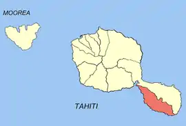
 Location of the commune (in red) within the Windward Islands | |
Location of Taiʻarapu-Ouest | |
| Coordinates: 17°50′S 149°17′W / 17.83°S 149.28°W | |
| Country | France |
| Overseas collectivity | French Polynesia |
| Subdivision | Windward Islands |
| Government | |
| • Mayor (2020–2026) | Tetuanui Hamblin[1] |
| Area 1 | 104.3 km2 (40.3 sq mi) |
| Population (2017) | 8,078 |
| • Density | 77/km2 (200/sq mi) |
| Time zone | UTC−10:00 |
| INSEE/Postal code | 98748 /98725 |
| Elevation | 0–1,306 m (0–4,285 ft) |
| 1 French Land Register data, which excludes lakes, ponds, glaciers > 1 km2 (0.386 sq mi or 247 acres) and river estuaries. | |
Taiʻarapu-Ouest (literally "Taiʻarapu West") is a commune of French Polynesia, an overseas territory of France in the Pacific Ocean. The commune of Taiʻarapu-Ouest is located on the island of Tahiti, in the administrative subdivision of the Windward Islands, themselves part of the Society Islands.[2] At the 2017 census it had a population of 8,078.[3]
The commune extends over half of the peninsula of Tahiti Iti ("small Tahiti", a.k.a. Taiʻarapu).
Taiʻarapu-Ouest consists of the following associated communes:
The administrative centre of the commune is the settlement of Vairao.[4]
Population
| Year | Pop. | ±% |
|---|---|---|
| 2002 | 6,081 | — |
| 2007 | 7,002 | +15.1% |
| 2012 | 7,639 | +9.1% |
| 2017 | 8,078 | +5.7% |
References
- ↑ "Répertoire national des élus: les maires" (in French). data.gouv.fr, Plateforme ouverte des données publiques françaises. 4 May 2022.
- ↑ Décret n° 2005-1611 du 20 décembre 2005 pris pour l'application du statut d'autonomie de la Polynésie française, Légifrance
- ↑ Répartition de la population en Polynésie française en 2017, Institut de la statistique de la Polynésie française
- ↑ Décret n°72-407 du 17 mai 1972 portant création de communes dans le territoire de la Polynésie française, Légifrance
Wikimedia Commons has media related to Taiarapu-Ouest.
This article is issued from Wikipedia. The text is licensed under Creative Commons - Attribution - Sharealike. Additional terms may apply for the media files.
