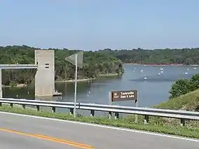
| Taylorsville Lake State Park | |
|---|---|
 | |
 Location in Kentucky  Taylorsville Lake State Park (the United States) | |
| Location | Spencer, Kentucky, United States |
| Coordinates | 38°01′50″N 85°15′20″W / 38.03056°N 85.25556°W |
| Area | 1,200 acres (4.9 km2) |
| Established | 1983[1] |
| Governing body | Kentucky Department of Parks |
| Website | Taylorsville Lake State Park |
| U.S. Geological Survey Geographic Names Information System: Taylorsville Lake State Park | |
Taylorsville Lake State Park is a park encompassing 1,200 acres (490 ha) in Spencer County, Kentucky, roughly midway between Louisville and Lexington. Taylorsville Lake, its major feature, extends into parts of Anderson County and Nelson County.[2]
Taylorsville Lake gains its name from the nearby town, named for President Zachary Taylor's father, Richard Taylor, who donated 60 acres (24 ha) of his own land for creation of the town.[1] The lake was created when the United States Army Corps of Engineers chose to dam the Salt River, thereby creating the lake, with its public opening in January 1983. The dam, which measures a height of 163 feet (50 m) and a length of 1,280 feet (390 m), cost $28.8 million to build. The resulting lake is 3,050 acres (1,230 ha) in total area, has 75 miles (121 km) of shoreline, and is 18 miles (29 km) long.[3]
Activities and amenities
There is both a park office, maintained by the state of Kentucky, and a visitors center maintained by the United States Army Corps of Engineers. The visitors center is pyramid-shaped with a brown metal roof, and contains displays of the local trees, boating, and dam management.[4]
Fishing is the main attraction, as Taylorsville Lake is the most heavily stocked lake in the Commonwealth of Kentucky;[1] it is known for its bluegill, and features bass and crappie. This is facilitated by a rule that bass must be 15 inches (38 cm) long, at minimum, to be legally caught and kept; crappie must be 9 inches (23 cm); bluegill are not sport fish and there is no minimum size.[5]
There are also 17.3 miles (27.8 km) of hiking trails in the park, but these are seen as poor quality by hiking enthusiasts as their use by equestrian traffic has made the hiking trails like "a plow had chattered down them". Camping was not available at the park until 1998.[3][6]
References
- 1 2 3 "History". Taylorsville Lake State Park. Kentucky Department of Parks. Retrieved September 12, 2013.
- ↑ Kleber, John E., ed. (1992). "Parks, State". The Kentucky Encyclopedia. Associate editors: Thomas D. Clark, Lowell H. Harrison, and James C. Klotter. Lexington, Kentucky: The University Press of Kentucky. ISBN 0-8131-1772-0.
- 1 2 Bailey, Bill (January 1, 1995). Kentucky State Parks. Glovebox Guidebooks of America. pp. 299–304. ISBN 1881139131.
- ↑ "Taylorsville Lake". United States Army Corps of Engineers Louisville District. Retrieved September 13, 2013.
- ↑ "2010 Fishing Regulations" (PDF). Kentucky Department of Fish and Wildlife Resources. pp. 5–6. Archived from the original (PDF) on November 4, 2010.
- ↑ Elliott, Brook & Barbara (May 12, 1998). Hiking Kentucky. Human Kinetics. p. 149. ISBN 0880118121.
External links
- Taylorsville Lake State Park Kentucky Department of Parks