Vrádište | |
|---|---|
Municipality | |
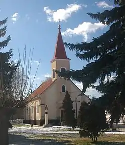 Church in Vrádište | |
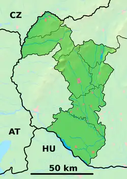 Vrádište Location of Vrádište in the Trnava Region  Vrádište Vrádište (Slovakia) | |
| Coordinates: 48°49′N 17°12′E / 48.817°N 17.200°E | |
| Country | Slovakia |
| Region | Trnava |
| District | Skalica |
| First mentioned | 1392 |
| Area | |
| • Total | 4.25[1] km2 (1.64[1] sq mi) |
| Elevation | 170[2] m (560[2] ft) |
| Population (2021) | |
| • Total | 841[3] |
| Time zone | UTC+1 (CET) |
| • Summer (DST) | UTC+2 (CEST) |
| Postal code | 908 49[2] |
| Area code | +421 34[2] |
| Car plate | SI |
| Website | vradiste.sk |
Vrádište (Hungarian: Várköz) is a village and municipality in Skalica District in the Trnava Region of western Slovakia.
History
In historical records the village was first mentioned in 1392.
Geography
The municipality lies at an altitude of 164 metres and covers an area of 4.251 km². It has a population of about 682 people.
Gallery
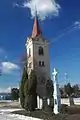 Bell tower
References
- 1 2 "Hustota obyvateľstva - obce [om7014rr_ukaz: Rozloha (Štvorcový meter)]". www.statistics.sk (in Slovak). Statistical Office of the Slovak Republic. 2022-03-31. Retrieved 2022-03-31.
- 1 2 3 4 "Základná charakteristika". www.statistics.sk (in Slovak). Statistical Office of the Slovak Republic. 2015-04-17. Retrieved 2022-03-31.
- ↑ "Počet obyvateľov podľa pohlavia - obce (ročne)". www.statistics.sk (in Slovak). Statistical Office of the Slovak Republic. 2022-03-31. Retrieved 2022-03-31.
External links
![]() Media related to Vrádište at Wikimedia Commons
Media related to Vrádište at Wikimedia Commons
- Official page
- https://web.archive.org/web/20071116010355/http://www.statistics.sk/mosmis/eng/run.html
Municipalities of Skalica District | ||
|---|---|---|
This article is issued from Wikipedia. The text is licensed under Creative Commons - Attribution - Sharealike. Additional terms may apply for the media files.