| Woodbridge | |
|---|---|
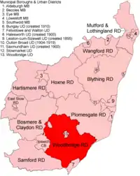
 Location within East Suffolk, 1894 | |
| History | |
| • Created | 1894 |
| • Abolished | 1934 |
| • Succeeded by | Deben Rural District |
| Status | Rural district |
Woodbridge Rural District was a rural district within the administrative county of East Suffolk between 1894 and 1934. It was created out of the earlier Woodbridge rural sanitary district.[1] It surrounded the town of Woodbridge, which had earlier been created as an urban district.
In 1934, under a County Review Order, Woodbridge Rural District was abolished and its parishes transferred to the new Deben Rural District.
Statistics
| Year | Area[2] | Population [3] |
Density (pop/ha) | |
|---|---|---|---|---|
| acres | ha | |||
| 1911 | 73,327 | 29,675 | 16,314 | 0.55 |
| 1921 | 16,046 | 0.54 | ||
| 1931 | 18,386 | 0.62 | ||
Parishes
Woodbridge RD contained the following parishes:
- Alderton
- Alnesbourn Priory
- Bawdsey
- Boulge
- Boyton
- Bredfield
- Brightwell
- Bromeswell
- Bucklesham
- Burgh
- Capel St Andrew
- Charsfield
- Clopton
- Culpho
- Dallinghoo
- Dallinghoo Wield
- Debach
- Falkenham
- Foxhall
- Great Bealings
- Grundisburgh
- Hasketon
- Hemley
- Hollesley
- Kesgrave
- Kirton
- Levington
- Little Bealings
- Martlesham
- Melton
- Nacton
- Newbourne
- Otley
- Pettistree
- Playford
- Purdis Farm
- Ramsholt
- Rushmere St Andrew
- Shottisham
- Stratton Hall
- Sutton
- Trimley St Martin
- Trimley St Mary
- Tuddenham St Martin
- Ufford
- Waldringfield
- Westerfield
- Witnesham
References
- ↑ "Woodbridge RD through time: Census tables with data for the Local Government District". A Vision of Britain through Time. GB Historical GIS / University of Portsmouth. Retrieved 10 July 2017.
- ↑ "Woodbridge RD through time: Population Statistics: Area (acres)". A Vision of Britain through Time. GB Historical GIS / University of Portsmouth. Retrieved 10 July 2017.
- ↑ "Woodbridge RD through time: Population Statistics: Total Population". A Vision of Britain through Time. GB Historical GIS / University of Portsmouth. Retrieved 10 July 2017.
52°04′N 1°17′E / 52.07°N 1.28°E
This article is issued from Wikipedia. The text is licensed under Creative Commons - Attribution - Sharealike. Additional terms may apply for the media files.