Xuecheng District
薛城区 | |
|---|---|
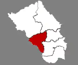
 Location in Zaozhuang | |
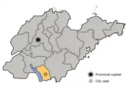
 Zaozhuang in Shandong | |
| Coordinates: 34°46′28″N 117°15′05″E / 34.77444°N 117.25139°E | |
| Country | People's Republic of China |
| Province | Shandong |
| Prefecture-level city | Zaozhuang |
| Area | |
| • Total | 423.02 km2 (163.33 sq mi) |
| Population (2016) | |
| • Total | 462,500 |
| • Density | 1,100/km2 (2,800/sq mi) |
| Time zone | UTC+8 (China Standard) |
| Postal code | 277000 |
Xuecheng (Chinese: 薛城区; pinyin: Xuēchéng Qū) is a district and the seat of Zaozhuang, Shandong province, China, ever named by "lin cheng ". It has an area of 506.72 km2 and around 405,285 inhabitants (2003). As of the end of 2022, the resident population of Xuecheng District was 485,637.[1]As of May 2022, Xuecheng District has five streets and four towns under its jurisdiction, with the district government stationed at No. 2 Yongfu Middle Road.[2]
Administrative divisions
As 2012, this district is divided to 3 subdistricts and 6 towns.[3]
- Subdistricts
- Lincheng Subdistrict (临城街道)
- Xingren Subdistrict (兴仁街道)
- Xingcheng Subdistrict (兴城街道)
- Towns
|
|
Climate
| Climate data for Xuecheng (1999–2020 normals, extremes 1981–2010) | |||||||||||||
|---|---|---|---|---|---|---|---|---|---|---|---|---|---|
| Month | Jan | Feb | Mar | Apr | May | Jun | Jul | Aug | Sep | Oct | Nov | Dec | Year |
| Record high °C (°F) | 16.7 (62.1) |
25.0 (77.0) |
28.2 (82.8) |
33.2 (91.8) |
37.9 (100.2) |
38.0 (100.4) |
39.9 (103.8) |
37.0 (98.6) |
35.5 (95.9) |
32.0 (89.6) |
25.9 (78.6) |
21.1 (70.0) |
39.9 (103.8) |
| Mean daily maximum °C (°F) | 5.5 (41.9) |
8.8 (47.8) |
15.1 (59.2) |
21.4 (70.5) |
26.9 (80.4) |
30.9 (87.6) |
31.7 (89.1) |
30.8 (87.4) |
27.3 (81.1) |
21.7 (71.1) |
14.1 (57.4) |
7.1 (44.8) |
20.1 (68.2) |
| Daily mean °C (°F) | 1.2 (34.2) |
4.1 (39.4) |
9.9 (49.8) |
16.0 (60.8) |
21.6 (70.9) |
25.8 (78.4) |
27.4 (81.3) |
26.7 (80.1) |
22.7 (72.9) |
16.9 (62.4) |
9.6 (49.3) |
3.0 (37.4) |
15.4 (59.7) |
| Mean daily minimum °C (°F) | −2.1 (28.2) |
0.5 (32.9) |
5.5 (41.9) |
11.3 (52.3) |
16.9 (62.4) |
21.4 (70.5) |
24.0 (75.2) |
23.4 (74.1) |
18.9 (66.0) |
12.9 (55.2) |
6.0 (42.8) |
−0.3 (31.5) |
11.5 (52.8) |
| Record low °C (°F) | −12.6 (9.3) |
−12.2 (10.0) |
−9.3 (15.3) |
−0.5 (31.1) |
4.7 (40.5) |
12.4 (54.3) |
16.5 (61.7) |
12.9 (55.2) |
6.8 (44.2) |
−1.0 (30.2) |
−8.5 (16.7) |
−12.4 (9.7) |
−12.6 (9.3) |
| Average precipitation mm (inches) | 13.2 (0.52) |
16.8 (0.66) |
18.1 (0.71) |
38.4 (1.51) |
66.4 (2.61) |
85.0 (3.35) |
239.5 (9.43) |
185.5 (7.30) |
72.7 (2.86) |
33.2 (1.31) |
32.7 (1.29) |
16.2 (0.64) |
817.7 (32.19) |
| Average precipitation days (≥ 0.1 mm) | 3.6 | 4.4 | 4.3 | 6.2 | 6.3 | 7.4 | 12.8 | 12.0 | 7.3 | 6.0 | 5.5 | 4.0 | 79.8 |
| Average snowy days | 3.0 | 2.6 | 0.5 | 0 | 0 | 0 | 0 | 0 | 0 | 0 | 0.5 | 1.3 | 7.9 |
| Average relative humidity (%) | 60 | 59 | 55 | 58 | 62 | 65 | 79 | 79 | 72 | 65 | 65 | 62 | 65 |
| Mean monthly sunshine hours | 133.6 | 137.0 | 193.2 | 212.6 | 226.1 | 197.3 | 176.7 | 171.8 | 162.1 | 161.1 | 146.3 | 145.7 | 2,063.5 |
| Percent possible sunshine | 43 | 44 | 52 | 54 | 52 | 46 | 40 | 42 | 44 | 46 | 48 | 48 | 47 |
| Source: China Meteorological Administration[4][5] | |||||||||||||
Xuecheng District belongs to the warm temperate monsoon continental climate, with significant continental climate characteristics.[6]
Geography
Xuecheng District, located in the south of Shandong Province, on the shore of Weishan Lake, with a total area of 422.71 square kilometers, is the resident of the People's Government of Zaozhuang City.[7]
Xuecheng District is located in the hilly area of Lunan and the Jianghuai Plain.The terrain is divided into three categories: plains, hills and depressions.The plains account for 50% of the total area, the hills for 34.1%, and the floodplains for 15.9%, with the lowest point being Panjiaduokou.[8]
References
- ↑ 薛城区人民政府 (2023-04-10). "薛城区2022年国民经济和社会发展统计公报" [Xuecheng District National Economic and Social Development Statistics Bulletin 2022]. xxgk.xuecheng.gov.cn. Retrieved 2023-12-13.
- ↑ 国家统计局, (China) National Bureau of Statistics (NBS) (2022-03-27). "薛城区行政代码" [Xuecheng District Administrative Code]. www.stats.gov.cn.
- ↑ 东营市-行政区划网 www.xzqh.org (in Chinese). XZQH. Retrieved 2012-05-24.
- ↑ 中国气象数据网 – WeatherBk Data (in Simplified Chinese). China Meteorological Administration. Retrieved 12 August 2023.
- ↑ 中国气象数据网 (in Simplified Chinese). China Meteorological Administration. Retrieved 12 August 2023.
- ↑ 山东省情网. "薛城区志". lib.sdsqw.cn. Retrieved 2023-12-13.
- ↑ 枣庄市人民政府. "机关介绍" [Introduction to the organization]. www.zaozhuang.gov.cn.
- ↑ 中共薛城区委党史研究中心(薛城区地方史志研究中心), Party History Research Center of Xuecheng District Committee of the Communist Party of China (Xuecheng District Local History Research Center) (2021). 薛城年鉴 [Xuecheng Yearbook] (in Chinese). Beijing: 团结出版社.