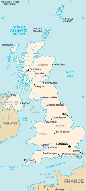
The United Kingdom

This is part of the list of United Kingdom locations: a gazetteer of place names in the United Kingdom showing each place's locality and geographical coordinates.

New (continued)

Newm

Location Locality Coordinates
(links to map & photo sources)
OS grid
reference
Newmachar Aberdeenshire 57°16′N 2°12′W / 57.26°N 02.20°W / 57.26; -02.20 NJ8819
Newmains North Lanarkshire 55°47′N 3°53′W / 55.78°N 03.88°W / 55.78; -03.88 NS8256
New Malden Kingston upon Thames 51°23′N 0°16′W / 51.39°N 00.26°W / 51.39; -00.26 TQ2168
Newman's End Essex 51°47′N 0°11′E / 51.78°N 00.18°E / 51.78; 00.18 TL5112
Newman's Green Suffolk 52°03′N 0°44′E / 52.05°N 00.74°E / 52.05; 00.74 TL8843
Newman's Place Herefordshire 52°08′N 3°02′W / 52.13°N 03.03°W / 52.13; -03.03 SO2949
Newmarket Gloucestershire 51°41′N 2°14′W / 51.68°N 02.23°W / 51.68; -02.23 ST8499
Newmarket Suffolk 52°14′N 0°24′E / 52.24°N 00.40°E / 52.24; 00.40 TL6463
Newmarket Western Isles 58°13′N 6°23′W / 58.22°N 06.39°W / 58.22; -06.39 NB4235
New Marske Redcar and Cleveland 54°34′N 1°02′W / 54.57°N 01.04°W / 54.57; -01.04 NZ6220
New Marston Oxfordshire 51°45′N 1°14′W / 51.75°N 01.24°W / 51.75; -01.24 SP5207
New Marton Shropshire 52°53′N 2°59′W / 52.89°N 02.99°W / 52.89; -02.99 SJ3334
New Micklefield Leeds 53°47′N 1°20′W / 53.78°N 01.33°W / 53.78; -01.33 SE4432
New Mill Cornwall 50°16′N 5°05′W / 50.26°N 05.08°W / 50.26; -05.08 SW8045
New Mill Cumbria 54°25′N 3°28′W / 54.42°N 03.46°W / 54.42; -03.46 NY0504
New Mill Hertfordshire 51°47′N 0°40′W / 51.79°N 00.66°W / 51.79; -00.66 SP9212
New Mill Kirklees 53°34′N 1°45′W / 53.56°N 01.75°W / 53.56; -01.75 SE1608
New Mill Scottish Borders 55°23′N 2°47′W / 55.38°N 02.79°W / 55.38; -02.79 NT5010
New Mill Wiltshire 51°20′N 1°44′W / 51.34°N 01.74°W / 51.34; -01.74 SU1861
Newmill Cornwall 50°09′N 5°34′W / 50.15°N 05.57°W / 50.15; -05.57 SW4534
Newmill Moray 57°33′N 2°57′W / 57.55°N 02.95°W / 57.55; -02.95 NJ4352
Newmill Scottish Borders 55°23′N 2°52′W / 55.38°N 02.86°W / 55.38; -02.86 NT4510
Newmillerdam Wakefield 53°38′N 1°31′W / 53.63°N 01.51°W / 53.63; -01.51 SE3215
New Mills Cheshire 53°20′N 2°20′W / 53.33°N 2.33°W / 53.33; -2.33 SJ7781
New Mills Cornwall 50°20′N 4°57′W / 50.33°N 04.95°W / 50.33; -04.95 SW9052
New Mills Derbyshire 54°25′N 3°28′W / 54.42°N 03.46°W / 54.42; -03.46 SJ9958
New Mills Gloucestershire 51°44′N 2°32′W / 51.73°N 02.53°W / 51.73; -02.53 SO6304
New Mills Herefordshire 52°02′N 2°26′W / 52.03°N 02.43°W / 52.03; -02.43 SO7038
New Mills Highland 57°38′N 4°14′W / 57.64°N 04.23°W / 57.64; -04.23 NH6764
New Mills Powys 52°35′N 3°20′W / 52.59°N 03.34°W / 52.59; -03.34 SJ0901
New Mills Scottish Borders 55°44′N 2°46′W / 55.73°N 02.76°W / 55.73; -02.76 NT5249
Newmills Fife 56°03′N 3°35′W / 56.05°N 03.59°W / 56.05; -03.59 NT0186
Newmiln Perth and Kinross 56°27′N 3°25′W / 56.45°N 03.42°W / 56.45; -03.42 NO1230
Newmilns East Ayrshire 55°36′N 4°21′W / 55.60°N 04.35°W / 55.60; -04.35 NS5237
New Milton Hampshire 50°45′N 1°40′W / 50.75°N 01.67°W / 50.75; -01.67 SZ2395
New Mistley Essex 51°56′N 1°05′E / 51.93°N 01.08°E / 51.93; 01.08 TM1231
New Moat Pembrokeshire 51°53′N 4°49′W / 51.88°N 04.82°W / 51.88; -04.82 SN0625
Newmore Highland 57°32′N 4°26′W / 57.53°N 04.44°W / 57.53; -04.44 NH5452
New Moston Manchester 53°31′N 2°10′W / 53.51°N 02.16°W / 53.51; -02.16 SD8902

Newn–Newo

Location Locality Coordinates
(links to map & photo sources)
OS grid
reference
Newnes Shropshire 52°54′N 2°55′W / 52.90°N 02.92°W / 52.90; -02.92 SJ3834
Newney Green Essex 51°44′N 0°23′E / 51.73°N 00.38°E / 51.73; 00.38 TL6507
Newnham Cambridgeshire 52°11′N 0°06′E / 52.19°N 00.10°E / 52.19; 00.10 TL4457
Newnham (Newnham on Severn) Gloucestershire 51°47′N 2°27′W / 51.79°N 02.45°W / 51.79; -02.45 SO6911
Newnham Hampshire 51°16′N 0°59′W / 51.27°N 00.99°W / 51.27; -00.99 SU7053
Newnham Hertfordshire 52°01′N 0°11′W / 52.01°N 00.19°W / 52.01; -00.19 TL2437
Newnham Kent 51°16′N 0°47′E / 51.27°N 00.79°E / 51.27; 00.79 TQ9557
Newnham Northamptonshire 52°13′N 1°10′W / 52.22°N 01.16°W / 52.22; -01.16 SP5759
Newnham Warwickshire 52°14′N 1°47′W / 52.23°N 01.78°W / 52.23; -01.78 SP1560
Newnham Bridge Worcestershire 52°19′N 2°31′W / 52.31°N 02.52°W / 52.31; -02.52 SO6469
New Ollerton Nottinghamshire 53°12′N 1°01′W / 53.20°N 01.01°W / 53.20; -01.01 SK6668
New Oscott Birmingham 52°32′N 1°51′W / 52.54°N 01.85°W / 52.54; -01.85 SP1094

Newp–Newq

Location Locality Coordinates
(links to map & photo sources)
OS grid
reference
New Pale Cheshire 53°14′N 2°43′W / 53.24°N 02.72°W / 53.24; -02.72 SJ5272
New Park North Yorkshire 53°59′N 1°33′W / 53.99°N 01.55°W / 53.99; -01.55 SE2956
New Parks City of Leicester 52°38′N 1°11′W / 52.64°N 01.18°W / 52.64; -01.18 SK5505
New Passage South Gloucestershire 51°34′N 2°40′W / 51.57°N 02.66°W / 51.57; -02.66 ST5486
New Pitsligo Aberdeenshire 57°35′N 2°12′W / 57.58°N 02.20°W / 57.58; -02.20 NJ8855
New Polzeath Cornwall 50°34′N 4°55′W / 50.57°N 04.92°W / 50.57; -04.92 SW9379
Newpool Staffordshire 53°06′N 2°11′W / 53.10°N 02.19°W / 53.10; -02.19 SJ8756
Newport Cornwall 50°38′N 4°22′W / 50.64°N 04.37°W / 50.64; -04.37 SX3285
Newport Devon 51°04′N 4°03′W / 51.06°N 04.05°W / 51.06; -04.05 SS5632
Newport Dorset 50°44′N 2°10′W / 50.74°N 02.17°W / 50.74; -02.17 SY8894
Newport East Riding of Yorkshire 53°45′N 0°43′W / 53.75°N 00.71°W / 53.75; -00.71 SE8530
Newport Essex 51°59′N 0°13′E / 51.98°N 00.21°E / 51.98; 00.21 TL5234
Newport Gloucestershire 51°40′N 2°26′W / 51.67°N 02.44°W / 51.67; -02.44 ST6997
Newport Highland 58°11′N 3°29′W / 58.19°N 03.49°W / 58.19; -03.49 ND1224
Newport Isle of Wight 50°41′N 1°18′W / 50.68°N 01.30°W / 50.68; -01.30 SZ4988
Newport City of Newport 51°35′N 2°59′W / 51.58°N 02.99°W / 51.58; -02.99 ST3188
Newport Norfolk 52°41′N 1°41′E / 52.68°N 01.69°E / 52.68; 01.69 TG5016
Newport Pembrokeshire 52°01′N 4°50′W / 52.01°N 04.84°W / 52.01; -04.84 SN0539
Newport Shropshire 52°46′N 2°23′W / 52.76°N 02.38°W / 52.76; -02.38 SJ7419
Newport Somerset 51°00′N 2°59′W / 51.00°N 02.98°W / 51.00; -02.98 ST3123
Newport-on-Tay Fife 56°26′N 2°57′W / 56.43°N 02.95°W / 56.43; -02.95 NO4127
Newport Pagnell Milton Keynes 52°04′N 0°44′W / 52.07°N 00.73°W / 52.07; -00.73 SP8743
Newpound Common West Sussex 51°02′N 0°29′W / 51.03°N 00.48°W / 51.03; -00.48 TQ0627
Newquay Cornwall 50°24′N 5°05′W / 50.40°N 05.08°W / 50.40; -05.08 SW8161
New Quay (Ceinewydd) Ceredigion 52°12′N 4°22′W / 52.20°N 04.37°W / 52.20; -04.37 SN3859

Newr

Location Locality Coordinates
(links to map & photo sources)
OS grid
reference
New Rackheath Norfolk 52°39′N 1°22′E / 52.65°N 01.37°E / 52.65; 01.37 TG2812
New Radnor Powys 52°14′N 3°09′W / 52.23°N 03.15°W / 52.23; -03.15 SO2160
New Ridley Northumberland 54°55′N 1°55′W / 54.92°N 01.92°W / 54.92; -01.92 NZ0559
New Road Side Bradford 53°44′N 1°46′W / 53.73°N 01.77°W / 53.73; -01.77 SE1527
New Road Side North Yorkshire 53°52′N 2°02′W / 53.87°N 02.04°W / 53.87; -02.04 SD9742
New Romney Kent 50°58′N 0°56′E / 50.97°N 00.93°E / 50.97; 00.93 TR0624
New Rossington Doncaster 53°28′N 1°05′W / 53.46°N 01.08°W / 53.46; -01.08 SK6197
New Row Ceredigion 52°20′N 3°53′W / 52.34°N 03.88°W / 52.34; -03.88 SN7273
New Row Lancashire 53°50′N 2°32′W / 53.83°N 02.54°W / 53.83; -02.54 SD6438

News

Location Locality Coordinates
(links to map & photo sources)
OS grid
reference
Newsam Green Leeds 53°46′N 1°27′W / 53.76°N 01.45°W / 53.76; -01.45 SE3630
New Sauchie Clackmannanshire 56°07′N 3°47′W / 56.12°N 03.78°W / 56.12; -03.78 NS8994
New Sawley Derbyshire 52°53′N 1°18′W / 52.88°N 01.30°W / 52.88; -01.30 SK4732
Newsbank Cheshire 53°11′N 2°15′W / 53.19°N 02.25°W / 53.19; -02.25 SJ8366
New Scarbro' Leeds 53°48′N 1°38′W / 53.80°N 01.63°W / 53.80; -01.63 SE2434
New Scone Perth and Kinross 56°25′N 3°25′W / 56.41°N 03.41°W / 56.41; -03.41 NO1326
Newsells Hertfordshire 52°01′N 0°01′E / 52.01°N 00.01°E / 52.01; 00.01 TL3837
Newsham Lancashire 53°49′N 2°44′W / 53.81°N 02.74°W / 53.81; -02.74 SD5136
Newsham (Richmondshire) North Yorkshire 54°29′N 1°50′W / 54.48°N 01.84°W / 54.48; -01.84 NZ1010
Newsham (Hambleton) North Yorkshire 54°15′N 1°26′W / 54.25°N 01.43°W / 54.25; -01.43 SE3784
Newsham Northumberland 55°06′N 1°32′W / 55.10°N 01.53°W / 55.10; -01.53 NZ3079
New Sharlston Wakefield 53°40′N 1°25′W / 53.67°N 01.42°W / 53.67; -01.42 SE3820
Newsholme Bradford 53°50′N 1°58′W / 53.84°N 01.97°W / 53.84; -01.97 SE0239
Newsholme East Riding of Yorkshire 53°45′N 0°55′W / 53.75°N 00.92°W / 53.75; -00.92 SE7129
Newsholme Lancashire 53°57′N 2°14′W / 53.95°N 02.24°W / 53.95; -02.24 SD8451
New Silksworth Sunderland 54°52′N 1°25′W / 54.87°N 01.42°W / 54.87; -01.42 NZ3753
New Skelton Redcar and Cleveland 54°33′N 0°59′W / 54.55°N 00.98°W / 54.55; -00.98 NZ6618
New Smithy Derbyshire 53°20′N 1°55′W / 53.33°N 01.92°W / 53.33; -01.92 SK0582
Newsome Kirklees 53°37′N 1°47′W / 53.62°N 01.78°W / 53.62; -01.78 SE1414
New Southgate Enfield 51°37′N 0°08′W / 51.61°N 00.13°W / 51.61; -00.13 TQ2992
New Springs Wigan 53°33′N 2°36′W / 53.55°N 02.60°W / 53.55; -02.60 SD6007
New Sprowston Norfolk 52°39′N 1°17′E / 52.65°N 01.29°E / 52.65; 01.29 TG2311
New Stanton Derbyshire 52°56′N 1°19′W / 52.94°N 01.31°W / 52.94; -01.31 SK4639
Newstead Nottinghamshire 53°04′N 1°14′W / 53.06°N 01.24°W / 53.06; -01.24 SK5152
Newstead Scottish Borders 55°35′N 2°41′W / 55.59°N 02.69°W / 55.59; -02.69 NT5634
Newstead Staffordshire 52°57′N 2°10′W / 52.95°N 02.16°W / 52.95; -02.16 SJ8940
Newstead Wakefield 53°37′N 1°25′W / 53.62°N 01.41°W / 53.62; -01.41 SE3914
New Stevenston North Lanarkshire 55°48′N 3°59′W / 55.80°N 03.98°W / 55.80; -03.98 NS7659
New Street Kent 51°21′N 0°19′E / 51.35°N 00.32°E / 51.35; 00.32 TQ6264
New Street Staffordshire 53°04′N 1°55′W / 53.06°N 01.92°W / 53.06; -01.92 SK0552
Newstreet Lane Shropshire 52°55′N 2°34′W / 52.92°N 02.56°W / 52.92; -02.56 SJ6237
New Swanage Dorset 50°37′N 1°58′W / 50.61°N 01.97°W / 50.61; -01.97 SZ0280
New Swannington Leicestershire 52°44′N 1°22′W / 52.73°N 01.37°W / 52.73; -01.37 SK4215

Newt

Newta–Newtom

Location Locality Coordinates
(links to map & photo sources)
OS grid
reference
Newtake Devon 50°31′N 3°35′W / 50.51°N 03.58°W / 50.51; -03.58 SX8870
New Thirsk North Yorkshire 54°13′N 1°21′W / 54.22°N 01.35°W / 54.22; -01.35 SE4281
Newthorpe North Yorkshire 53°47′N 1°17′W / 53.78°N 01.28°W / 53.78; -01.28 SE4732
Newthorpe Nottinghamshire 53°00′N 1°17′W / 53.00°N 01.28°W / 53.00; -01.28 SK4846
Newthorpe Common Nottinghamshire 53°00′N 1°18′W / 53.00°N 01.30°W / 53.00; -01.30 SK4745
New Thundersley Essex 51°34′N 0°33′E / 51.57°N 00.55°E / 51.57; 00.55 TQ7789
Newtoft Lincolnshire 53°22′N 0°26′W / 53.36°N 00.43°W / 53.36; -00.43 TF0486
This article is issued from Wikipedia. The text is licensed under Creative Commons - Attribution - Sharealike. Additional terms may apply for the media files.